File:ChernobylEuropeCut2a.jpg

Size of this preview: 625 × 599 pixels. Other resolutions: 250 × 240 pixels | 1,074 × 1,030 pixels.
Original file (1,074 × 1,030 pixels, file size: 483 KB, MIME type: image/jpeg)

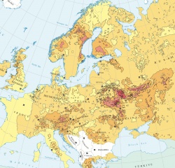
Cut from the map of contamination of Europe with Cs-137 for y.2008 from the [1] The cut of the scale is shown at right.
![Map or contamination after the Fukushima disaster for 2011 November 11 by [2]](/t/index.php/File:AJ2011111217322M.jpg)
The map can be compared to that after the Fukushima disaster by [2] shown at left.
References
- ↑ http://www.unscear.org/unscear/en/publications/2008_2.html Source of the map. (2008)
- ↑ 2.0 2.1 http://ajw.asahi.com/article/0311disaster/fukushima/AJ2011111217258 Radioactive cesium spread as far as Gunma-Nagano border. November 12, 2011.
File history
Click on a date/time to view the file as it appeared at that time.
| Date/Time | Thumbnail | Dimensions | User | Comment | |
|---|---|---|---|---|---|
| current | 17:50, 20 June 2013 | | 1,074 × 1,030 (483 KB) | Maintenance script (talk | contribs) | Importing image file |
- You cannot overwrite this file.
File usage
The following 3 pages link to this file: