File:AJ2011111217322M.jpg
No higher resolution available.
AJ2011111217322M.jpg (375 × 375 pixels, file size: 156 KB, MIME type: image/jpeg)
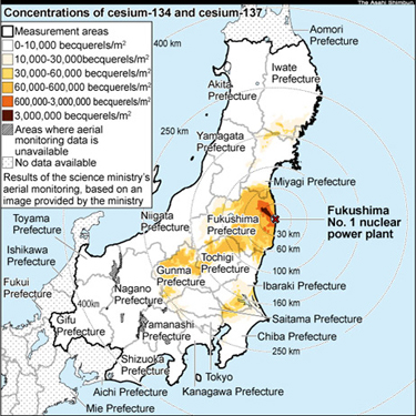
Map of contamination after the Fukushima disaster reported by Asahi Shinbun for 2012 November 11 [1].
The image is owned by the Asahi Shinbun, For the commercial use, communicate Aasahi. In any case of use, the source should be attributed.
References
- ↑ http://ajw.asahi.com/article/0311disaster/fukushima/AJ2011111217258 Radioactive cesium spread as far as Gunma-Nagano border. November 12, 2011. (for year 2018, the link fails)
File history
Click on a date/time to view the file as it appeared at that time.
| Date/Time | Thumbnail | Dimensions | User | Comment | |
|---|---|---|---|---|---|
| current | 17:50, 20 June 2013 | | 375 × 375 (156 KB) | Maintenance script (talk | contribs) | Importing image file |
- You cannot overwrite this file.
File usage
The following 6 pages link to this file: