Search results
Create the page "Ocean" on this wiki! See also the search results found.
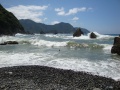
File:00055shokowaves.jpg Devchonka swims in the ocean waves. [[Category:Ocean]](2,048 × 1,536 (1.42 MB)) - 08:21, 1 December 2018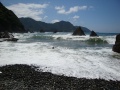
File:00056shokowaves.jpg Devchonka swims in the ocean waves. [[Category:Ocean]](2,048 × 1,536 (1.28 MB)) - 08:21, 1 December 2018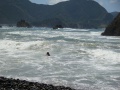
File:00057shokowaves.jpg Devchonka swims in the ocean waves. [[Category:Ocean]](2,048 × 1,536 (1.39 MB)) - 08:23, 1 December 2018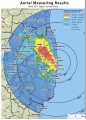
File:Fukushima 180511.jpg The ocean that does not keep the high concentration of depsited isotopes is painted w ...s rains, the most or this dust will be washed out to the rivers and to the Ocean. As for the soil... One needs to see detailed map of the distribution of th(650 × 904 (255 KB)) - 09:38, 21 June 2013
File:Newton2011 7 27b.jpg The intermediate blue represents the Pacific Ocean, that does not show its contamination at the aerial view.(1,025 × 1,377 (81 KB)) - 09:38, 21 June 2013
File:SeregaFunction03.png [[Category:Ocean waves]](2,509 × 434 (51 KB)) - 08:51, 1 December 2018
File:01928shoko.jpg Devchonka and Ocean.(2,048 × 1,536 (1.44 MB)) - 20:33, 20 June 2013
File:00055shokowaves.Fragment.jpg Devchonka swims in the ocean waves. [[Category:Ocean]](384 × 336 (12 KB)) - 08:21, 1 December 2018
File:02707crash.jpg ...ma Island]], about 100 kilometres (60 miles) south of Tokyo in the Pacific Ocean, according to NHK.(2,048 × 1,536 (1.4 MB)) - 08:24, 1 December 2018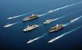
File:Fleet 5 nations.jpg ...74), Charles de Gaulle (R91), Surcouf (F 711); USS Port Royal (CG-73), HMS Ocean (L12), USS John F. Kennedy (CV-67), ITS Luigi Durand de la Penne (D560); an ...4), Charles de Gaulle (R 91), Surcouf (F 711), USS Port Royal (CG-73), HMS Ocean (L 12), USS John F. Kennedy (CV-67), ITS Luigi Durand de la Penne (D 560),(3,000 × 1,829 (2.01 MB)) - 08:36, 1 December 2018
File:IrQHDeamBW.jpg Black and white version of the [[Ocean of dreams]], loaded as(900 × 506 (143 KB)) - 08:38, 1 December 2018
File:IrQHDeamiVk.jpg [[Collapse of RF]]: Ocean of dreams(738 × 515 (104 KB)) - 08:38, 1 December 2018
File:Losharis.png ...inst the underwater cable and installs the [[kuzkinamat]] at the bottom of ocean.(598 × 405 (481 KB)) - 10:07, 13 June 2020
File:Greta00.jpg ...dn't be standing here. I should be back in school on the other side of the ocean," Thunberg said with tears in her eyes. "Yet you all come to me for hope? H(1,300 × 975 (69 KB)) - 02:18, 21 June 2020
File:Tira01.jpg Map of travel of prehistoric humans by Pacific Ocean from Aztlan (Asia?) to Mexico (Central America)(920 × 690 (405 KB)) - 16:14, 21 September 2021
File:1940.12.08.ChurchillRoosevelt.jpg ...heir control of the Atlantic and Indian Oceans. The control of the Pacific Ocean by the US Navy and the Atlantic by the British Navy is essential for our se(540 × 992 (185 KB)) - 09:40, 2 June 2022
File:TJLmnVDptKyGwMASEMvBq0vPa62bp8pR.jpg ...pleted, connect Finland, and by extension Sweden and Europe, to the Arctic Ocean and the Northern Sea Route.9) ...ina is the plan to cut off “Chinese shipping supplies through the Indian Ocean”,11) and thus Indian strategists worry that Beijing’s access to Arctic(1,880 × 1,160 (222 KB)) - 20:36, 22 July 2022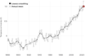
File:NasaGlobalTemperature2024big8.png GLOBAL LAND-OCEAN TEMPERATURE INDEX Land-Ocean Temperature Index (C)(1,692 × 1,134 (53 KB)) - 07:19, 2 August 2024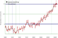
File:NasaGlobalTemperature2024compare.png Land-Ocean Temperature Index (C)(1,714 × 1,120 (67 KB)) - 07:19, 4 August 2024
File:WarmingNASAquadratic2024.png Land-Ocean Temperature Index (C) ...a/Global_Mean_Estimates_based_on_Land_and_Ocean_Data/graph.txt (2024) Land-Ocean Temperature Index (C)(1,156 × 409 (16 KB)) - 07:25, 4 August 2024


