1964.10.16.Test
1964.10.16.Test is explosion of the nuclear device at desert of Xinjiang, China.
The same event is denoted also with term "596" - The Chinese Atomic Bomb
[1]. The following estimates are suggested:
Type: Tower, 102m
Mass of the device: 1550kg
energy: 22 kt TNT \( \approx 92 \times 10^{12} \)Joule
Time: 1964.10.16, 07:00 GMT
Coordinates:
42.35, 88.30 by nti[1][6]
40.81246, 89.7901 by Wikipedia [2]
Doubts about Location
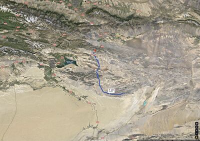
Roughly, the 1964.10.16.Test had been performed at the east side of the Kaklamakan Desert and North-Sest side of the Gobi desert, in vicinity of the dried lake Lop Mur.
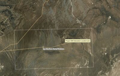
In the literature, position of the explosion is not well established. For the coordinates, the following estimates are observed:
42.35 , \(\phantom{1.}\) 88.30 by the nuclearweaponarchive [1] and nti [6]
40.81246, 89.7901 by Wikipedia [2]
40.80894, 89.7886 by Wikimapia [7]
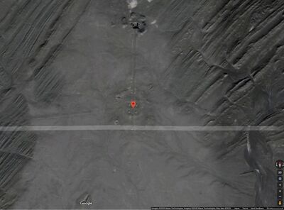
40.81247, 89.79012 by Googlemap
[8]. Some rectangular structure is seen that can be interpreted as traces of four posts of the tower where the device had been deteriorated). However, even in this case, it is difficult to determine, was that result of namely 1964.10.16.Test or other explosions performed later.
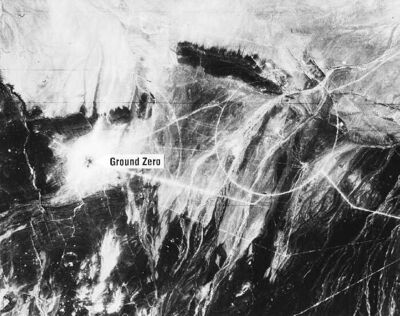
There is also satellite picture of the place of explosion by the nuclearweaponarchive [5], see last map at right. The specification reads: Lop Nur Nuclear Test Range four days after the test of "596". Image taken by a KH-4 Corona intelligence satellite.
However it is difficult to identify the place shown at the image [5] with any of the maps above.
45 nuclear tests
1964.10.16.Test is followed by many other nuclear explosions in that region.
The New York Times indicates, that "China conducted 45 nuclear tests at its remote Lop Nur site in the western region of Xinjiang, including 23 in the atmosphere, from 1964 until it signed the Comprehensive Nuclear Test Ban Treaty in 1996." [9]
The area of testing is contaminated with unstable isotopes, affecting the population. Jun Takada estimates, that off order of million people in the nearby areas received doses high enough to induce leukemia, solid cancers and fetal damage. Hundreds thousand people are believed to die of these illness. [10]
The testing includes the dropping of bombs from aircrafts [11] at place with coordinates
40.78668, 89.72624
The mark used to navigate pilots is seen at the maps of century 21:
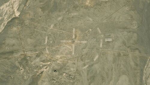
The dashed circle drown at the ground has diameter approximately 300 meter.
References
- ↑ 1.0 1.1 1.2 1.3 http://nuclearweaponarchive.org/China/ChinaTesting.html "596" - The Chinese Atomic Bomb// Test: "596" // Time: 07:00 16 October 1964 (GMT) // Location: Lop Nur Test Ground, // 42.35 N, 88.30 E // Test Height and Type: Tower, 102 m // Yield: 22 Kt // This pure-fission U-235 implosion fission device named "596" was China's first nuclear test. The device weighed 1550 kg.
- ↑ 2.0 2.1 2.2 https://en.wikipedia.org/wiki/List_of_nuclear_weapons_tests_of_China (2020.05.22) .. Project 596 16 October 1964 07:00:?? Area D (Drop Area), Lop Nur, China 40.81246°N 89.7901°E 807 m (2,648 ft) + 102 m (335 ft) tower, NGB 22 kt [2][3][4] This pure-fission U-235 implosion fission device named "596" was China's first nuclear test. The device weighed 1,550 kg (3,420 lb). No plutonium was available at that time. ..
- ↑ http://wikimapia.org/#lang=ja&lat=40.808612&lon=89.788170&z=12&m=bs&show=/22665510/Lop-Nur-Above-Ground-Test-Area&search=40.785824%2C%2089.729338
- ↑ https://www.google.com/maps/place/40°48'44.9%22N+89°47'24.4%22E/@40.8126407,89.7890401,421m/data=!3m1!1e3!4m5!3m4!1s0x0:0x0!8m2!3d40.81247!4d89.7901
- ↑ 5.0 5.1 5.2 http://nuclearweaponarchive.org/China/ChinaTesting.html China's Nuclear Weapons China's Nuclear Program Last changed 1 May 2001 "596" - The Chinese Atomic Bomb Test: "596" Time: 07:00 16 October 1964 (GMT) Location: Lop Nur Test Ground, 42.35 N, 88.30 E Test Height and Type: Tower, 102 m Yield: 22 Kt This pure-fission U-235 implosion fission device named "596" was China's first nuclear test. The device weighed 1550 kg. No plutonium was available at this time. "596" on the way to the tower .. Lop Nur Nuclear Test Range four days after the test of "596". Image taken by a KH-4 Corona intelligence satellite.
- ↑ 6.0 6.1 https://www.nti.org/learn/facilities/710/ LOP NOR NUCLEAR WEAPONS TEST BASE. LAST UPDATED: July 26, 2012 OTHER NAME: 罗布泊核试验基地; Lop Nur LOCATION: Xinjiang Autonomous Region, China SUBORDINATE TO: General Armaments Department (GAD) SIZE: Approximately 100,000 square kilometers FACILITY STATUS: Research and training facilities operational. Last official test: 29 July 1996. Lop Nor is China’s only nuclear weapons test site, conducts nuclear weapons training and may be a major nuclear weapons stockpile location. [1] The Lop Nor test site covers 100,000 square kilometers, making it the largest in the world by a factor of almost twenty. [2] Approximately 20,000 square kilometers have been used for nuclear testing purposes, with such a large size attributed to the full spectrum of nuclear tests conducted at this single location. [3]// China formally established the Lop Nor Nuclear Test Base on 16 October 1959 with Soviet assistance in selection of the site. [4] Lop Nor was the site of China’s first nuclear test, with ground zero located at approximately 42.35N, 88.30E. [5] Subsequent tests have been conducted on towers, from airplanes, by missiles, underground and in the atmosphere. [6] ..
- ↑ http://wikimapia.org/#lang=ja&lat=40.808937&lon=89.788599&z=17&m=bs&show=/22665510/Lop-Nur-Above-Ground-Test-Area&search=40.785824%2C%2089.729338
- ↑ https://www.google.com/maps/place/40°48'32.2%22N+89°47'19.0%22E/@40.812673,89.7886189,421m/data=!3m1!1e3!4m5!3m4!1s0x0:0x0!8m2!3d40.80894!4d89.7886
- ↑ https://www.nytimes.com/2008/01/28/world/asia/28china.html David Lague. China Now Pays Troops Involved in Nuclear Tests. Jan. 28, 2008. BEIJING China has begun paying military personnel involved in nuclear tests, as part of its effort to improve benefits for veterans, the state news media reported over the weekend. // In the first public acknowledgment of the new benefit, the minister of civil affairs, Li Xueju, said that the government had started the “subsidies” to veterans of nuclear tests last year, the official Xinhua news agency reported late Saturday. // In a visit to a unit of the People’s Armed Police on Friday, Mr. Li said the government paid 15.12 billion yuan, or more than $2 billion last year, to more than eight million veterans and families of service personnel killed in combat or in public service, an increase of 34.8 percent over outlays in 2006, Xinhua said. // The total included payments to “some military personnel and civilians” who had taken part in nuclear tests, Xinhua reported Mr. Li as saying, without details. // China conducted 45 nuclear tests at its remote Lop Nur site in the western region of Xinjiang, including 23 in the atmosphere, from 1964 until it signed the Comprehensive Nuclear Test Ban Treaty in 1996. // Beijing maintains tight secrecy about its nuclear weapons program, and access to the Lop Nur site and the surrounding region is tightly restricted. ..
- ↑ https://www.scientificamerican.com/article/did-chinas-nuclear-tests/ Did China's Nuclear Tests Kill Thousands and Doom Future Generations? Radioactive clouds hung over villagers as China detonated nuclear bombs in the air for four decades. By Zeeya Merali on July 1, 2009. Enver Tohti remembers the week that it rained dust. That summer of 1973 he was in elementary school in Xinjiang Province, China’s westernmost region, which is inhabited mostly by Uygurs, one of the country’s minority ethnic groups. “There were three days that earth fell from the sky, without wind or any sort of storm. The sky was deadly silent—no sun, no moon,” he recalls. When the kids asked what was happening, the teacher told them that there was a storm on Saturn (its Chinese name translates into “soil planet”). Tohti believed her. It was only years later that he realized it was radioactive dust raised by the test detonation of a nuclear bomb within the province. // Three decades on, Tohti, now a medical doctor, is launching an investigation into the toll still being taken—and one that the Chinese government steadfastly refuses to acknowledge. A few hundred thousand people may have died as a result of radiation from at least 40 nuclear explosions carried out between 1964 and 1996 at the Lop Nur site in Xinjiang, which lies on the Silk Road. Almost 20 million people reside in Xinjiang, and Tohti believes that they offer unique insight into the long-term impact of radiation, including the relatively little studied genetic effects that may be handed down over generations. He is establishing the Lop Nur project at Sapporo Medical University in Japan with physicist Jun Takada to evaluate these consequences. // “It is a sad opportunity, but it is an opportunity nonetheless to both learn something new and replicate what we think we are seeing elsewhere,” observes Anders Møller, who co-directs the Chernobyl Research Initiative (CRI) and is based at the National Center for Scientific Research in Paris. // Takada has calculated that the peak radiation dose in Xinjiang exceeded that measured on the roof of the Chernobyl nuclear reactor after it melted down in 1986. Most damage to Xinjiang locals came from detonations during the 1960s and 1970s, which rained down a mixture of radioactive material and sand from the surrounding desert. Some were three-megaton explosions, 200 times larger than the bomb dropped on Hiroshima, says Takada, who published his findings in a book, Chinese Nuclear Tests (Iryokagakusha, 2009). // In the early 1990s Takada, who studied radiation effects from tests conducted by the U.S., the former Soviet Union and France, was invited by scientists in Kazakhstan, which borders Xinjiang, to evaluate the hazard from Chinese tests. He devised a computer model to estimate fallout patterns using Soviet records of detonation size and wind velocity as well as radiation levels measured in Kazakhstan from 1995 to 2002. Takada was not allowed into China, so he extrapolated his model and used information about the population density in Xinjiang to estimate that 194,000 people would have died as a result of acute radiation exposure. Around 1.2 million received doses high enough to induce leukemia, solid cancers and fetal damage. “My estimate is a conservative minimum,” Takada says. ..
- ↑ http://wikimapia.org/#lang=ja&lat=40.786683&lon=89.726240&z=19&m=bs&show=/22665510/Lop-Nur-Above-Ground-Test-Area&search=40.785824%2C%2089.729338
