Difference between revisions of "File:FigMap1989.jpg"
| Line 1: | Line 1: | ||
| + | Map of levels of [[Cs137]] deposition in 1989 in Belarus, the Russian Federation and Ukraine. |
||
| + | Figure II of report |
||
| + | <ref> |
||
| + | http://www.unscear.org/docs/publications/2008/UNSCEAR_2008_Annex-D-CORR.pdf |
||
| + | SOURCES AND EFFECTS OF IONIZING RADIATION |
||
| + | United Nations Scientific Committee on the Effects of Atomic Radiation |
||
| + | UNSCEAR 2008 |
||
| + | Report to the General Assembly with Scientific Annexes |
||
| + | VOLUME II Scientific Annexes C, D and E |
||
| + | UNITED NATIONS New York, 2011. |
||
| + | NOTE |
||
| + | The report of the Committee without its annexes appears as Official Records of the General |
||
| + | Assembly, Sixty-third Session, Supplement No. 46. |
||
| + | The designations employed and the presentation of material in this publication do not imply the expression of any opinion whatsoever on the part of the Secretariat of the United Nations concerning the legal status of any country, territory, city or area, or of its authorities, or concerning the delimitation of its frontiers or boundaries. |
||
| + | The country names used in this document are, in most cases, those that were in use at the time the data were collected or the text prepared. In other cases, however, the names have been updated, where this was possible and appropriate, to reflect political changes. |
||
| + | </ref>, page 51. |
||
| + | |||
| + | See the original for the best resolution. |
||
| + | |||
| + | ==Description== |
||
| + | The report reads: |
||
| + | |||
| + | 15. Material was deposited, mainly because of rainfall, in a complex pattern over large areas of the three republics and beyond. Owing to the emergency situation and the short half-life of [[I-131]], few reliable measurements of the pattern of radioiodine deposition were made. There are ongoing efforts to reconstruct the deposition pattern of [[I-131]], |
||
| + | using measurements of the long-lived [[I-129]] as an analogue. Three main areas of the former Soviet Union (in total, 150,000 km<sup>2</sup> with more than 5 million inhabitants) were classified as contaminated areas (figure II). |
||
| + | |||
| + | For some reason, the text discuss distribution of isotopes of iodine,<br> |
||
| + | while the caption of the figure indicates, that it refers to distribution of [[Cs137]]. |
||
| + | |||
| + | ==References== |
||
| + | <references/> |
||
| + | |||
| + | [[Category:Balarus]] |
||
| + | [[Category:Chernobyl disaster]] |
||
| + | [[Category:Cs137]] |
||
| + | [[Category:History]] |
||
| + | [[Category:Map]] |
||
| + | [[Category:Russia]] |
||
| + | [[Category:Ukraine]] |
||
Latest revision as of 03:50, 19 February 2020
Map of levels of Cs137 deposition in 1989 in Belarus, the Russian Federation and Ukraine. Figure II of report [1], page 51.
See the original for the best resolution.
Description
The report reads:
15. Material was deposited, mainly because of rainfall, in a complex pattern over large areas of the three republics and beyond. Owing to the emergency situation and the short half-life of I-131, few reliable measurements of the pattern of radioiodine deposition were made. There are ongoing efforts to reconstruct the deposition pattern of I-131, using measurements of the long-lived I-129 as an analogue. Three main areas of the former Soviet Union (in total, 150,000 km2 with more than 5 million inhabitants) were classified as contaminated areas (figure II).
For some reason, the text discuss distribution of isotopes of iodine,
while the caption of the figure indicates, that it refers to distribution of Cs137.
References
- ↑ http://www.unscear.org/docs/publications/2008/UNSCEAR_2008_Annex-D-CORR.pdf SOURCES AND EFFECTS OF IONIZING RADIATION United Nations Scientific Committee on the Effects of Atomic Radiation UNSCEAR 2008 Report to the General Assembly with Scientific Annexes VOLUME II Scientific Annexes C, D and E UNITED NATIONS New York, 2011. NOTE The report of the Committee without its annexes appears as Official Records of the General Assembly, Sixty-third Session, Supplement No. 46. The designations employed and the presentation of material in this publication do not imply the expression of any opinion whatsoever on the part of the Secretariat of the United Nations concerning the legal status of any country, territory, city or area, or of its authorities, or concerning the delimitation of its frontiers or boundaries. The country names used in this document are, in most cases, those that were in use at the time the data were collected or the text prepared. In other cases, however, the names have been updated, where this was possible and appropriate, to reflect political changes.
File history
Click on a date/time to view the file as it appeared at that time.
| Date/Time | Thumbnail | Dimensions | User | Comment | |
|---|---|---|---|---|---|
| current | 03:49, 19 February 2020 | 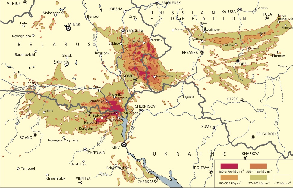 | 972 × 625 (221 KB) | T (talk | contribs) |
- You cannot overwrite this file.
File usage
The following page links to this file: