Difference between revisions of "File:Gaza Strip map2.png"
(Maintenance script uploaded "File:Gaza Strip map2.png": Importing image file) |
|||
| Line 16: | Line 16: | ||
Please attribute the source(s) at the redistribution |
Please attribute the source(s) at the redistribution |
||
| + | |||
| + | [[Category:Gasa Strip]] |
||
| + | [[Category:Map]] |
||
Latest revision as of 10:58, 21 June 2013
Copy from http://www.wikilivres.info/wiki/Image:Gaza_Strip_map2.svg and from http://commons.wikimedia.org/wiki/File:Gaza_Strip_map2.svg
English: Map of Gaza Strip, Stand December 2008 (SVG version of File:Gaza Strip map.png by Lencer)
Français : Carte de la bande de Gaza (décembre 2008)
SVG version of File:Gaza_Strip_map.png, created using Inkscape v. 0.46. with help from GIMP 2.4.7.:
For Country Borders: UN Office for the Coordination of Humanitarian Affairs, Gaza-Strip Overview Map
For roads, text, and population areas, I traced/typed from File:Gaza_Strip_map.png Minimap made using Israel location map.svg by User:NordNordWest
Colours in the main map were changed to those in w:Wikipedia:WikiProject_Maps#Map_colors
Please attribute the source(s) at the redistribution
File history
Click on a date/time to view the file as it appeared at that time.
| Date/Time | Thumbnail | Dimensions | User | Comment | |
|---|---|---|---|---|---|
| current | 17:50, 20 June 2013 | 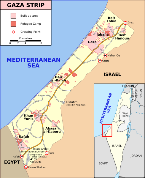 | 489 × 599 (134 KB) | Maintenance script (talk | contribs) | Importing image file |
- You cannot overwrite this file.
File usage
The following page links to this file: