File:47ae1 F59A51E334FB791F36AB413B5BC15C0C.jpg
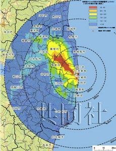
Poor-quality image, that could be used as button leading to the map of nuclear contamination of Japan in 2011 from [1]. There seem to be some bug in that site, the icon is not clickable and it does not show the map; the only icon is available. Qualitatively, it agrees with the maps shown in the article Fukushima disaster: the Trend to the North-West and then, orthogonal trend to the South–West. Up to May 18, no official quantitative contour plot seem to be available in the network. If someone finds the map, will you bring the link, please.
Copyright issue: The map of contamination should be available for free and cannot be subject to the distribution restriction.
References
- ↑ http://www.cnkeyword.info/japan-drawn-with-the-united-states-announced-nuclear-radiation-contamination-map-figure/ Japan drawn with the United States announced nuclear radiation contamination map (Figure) May 6, 2011.
File history
Click on a date/time to view the file as it appeared at that time.
| Date/Time | Thumbnail | Dimensions | User | Comment | |
|---|---|---|---|---|---|
| current | 17:49, 20 June 2013 | | 230 × 300 (25 KB) | Maintenance script (talk | contribs) | Importing image file |
- You cannot overwrite this file.
File usage
There are no pages that link to this file.