File:IwateTsunamiStone50ma.jpg
Summary
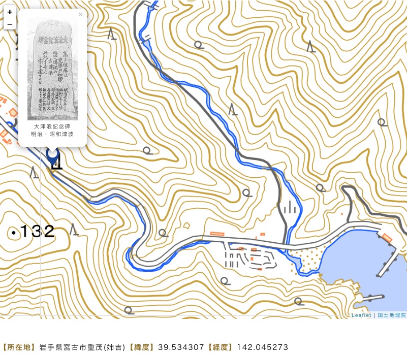
Iwate Tsunami stone at the map[1].
Address: Dai 10 Chiwari-19 Omoe, Miyako, Iwate 027-0111
Coordinates: 39.5343,142.0453
Elevation: 50m
The frame of the map shows piece of land of size of order of a kilometer.
The tsunami stone is of order of a half km away from the sea.
The time interval between the earthquake and tsunami is or order of halhhour.
The people had enough time to pick up their documents, children and escape:
Either to the tsunami stone, up the hill, with a car, with a bicile or just walking,
or, if in a boat, running away from the land.
The tsunami stone is supposed to provide the people the important information to save their life.
References
- ↑ https://web.archive.org/web/20230324211105/https://takuhon.lab.irides.tohoku.ac.jp/hibun/detail/iwate77/ 碑名:大津浪記念碑 (2022) 資料概要 【碑銘】 大津浪記念碑 【建立年】 - 【施主】 - 【施主分類】 - 【建立場所】 沿道 【対象災害】 明治・昭和津波 【大きさ】 高130㎝幅60㎝厚33㎝ 【タグ】 - 【所在地】岩手県宮古市重茂(姉吉)【緯度】39.534307【経度】142.045273 【地点備考】-
File history
Click on a date/time to view the file as it appeared at that time.
| Date/Time | Thumbnail | Dimensions | User | Comment | |
|---|---|---|---|---|---|
| current | 08:57, 7 October 2023 | | 801 × 697 (292 KB) | T (talk | contribs) | <div style="margin:-18px -14px 0px -200px; background-color:#fff"> <div style="margin:0px 0px 0px 30px; line-height:1.2em"><br> Iwate Tsunami stone at the map<ref> https://web.archive.org/web/20230324211105/https://takuhon.lab.irides.tohoku.ac.jp/... |
- You cannot overwrite this file.
File usage
The following page links to this file: