Difference between revisions of "Tsunami warning stone"
| Line 46: | Line 46: | ||
==New [[Tsunami warning stones]]== |
==New [[Tsunami warning stones]]== |
||
| − | Since the [[ |
+ | Since the [[Fukushima disaster]], caused by the [[tsunami]] 2011.03.11, many new [[Tsunami warning stone]]a are built-up, and they seem to be better documented. |
At least, their coordinates are published |
At least, their coordinates are published |
||
<ref> |
<ref> |
||
Revision as of 16:06, 29 December 2018
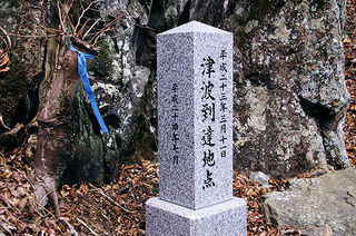
 Tsunami warning stone built up in Japan in 2012
[1]
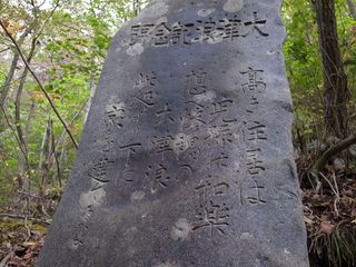
 Tsunami warning stone by M.Fackler, 2015
[2]
Tsunami warning stone or Tsunami stone may refer to a stone monument, that indicates the highest level of other reached at tsunami, in order to warn the future generations.
Lack of information
The kanji at at the tsunami warning stone are believed to mean somethinf like
Beware of tsunami. Do not build homes below this level.
However, this is only guess, as the original text, written at a tsunami warning stone is usually not typed.
The text, suggested in the descriptions (even id the description is in Japanese) does not match the kanji written at the stone.
Several authors suggest images of various Tsunami warning stones.
These images are characterized in the following:
1. The authors do not type the original text written in the stones. (Some translations are available.)
2. The authors to not indicate the coordinates of the place, where the Tsunami warning stone is located.
These two observations repeat in many publications and can be considered as surely observed phenomenon.
Origin of this phenomenon can be subject of the scientific research. It is difficult to guess a honest reason, why an author (or the censor) would omit the most important information from the description of the image.
New Tsunami warning stones
Since the Fukushima disaster, caused by the tsunami 2011.03.11, many new Tsunami warning stonea are built-up, and they seem to be better documented. At least, their coordinates are published [3]:
Unosumai-chō 鵜住ऺ Latitude: 39.329010N Longitude: 141.900560E The first one was installed in the pine wood (39.32901N,141.90056E) on the shore in Kamaishi city, Iwate prefecture, famous for its ironworks (now suspended) which has a brave Rugby team, where a pile of debris is waiting to be disposed. The design was placed with a famous industrial designer, the inscription was too sophisticated, the engraved characters “ニ千十一(=2011)” which looks like Rune letters, are difficult to decipher even for Japanese people.
The second stone was placed in the playground (38.76654N,141.50703E) of Koizumi kindergarden & elementary school on the hill in Kesennuma city, Miyagi prefecture. The Lessons from the Tsunami Experiment : To the people in the future, On 11 March 2011 2:46 PM, Tōhoku earthquake occurred, and the tsunami attacked the Pacific coastline.
The third one was put beside (39.20900N,141.88519E) the old tablets of Tōni (唐丹) village in Kamaishi city. The selection committee for the inscription decided to engrave all the entries, 91 from children and 4 from adults. Koizumi area in Kesennuma city suffered a severe damage, So many lives and houses were lost. The lessons from the tsunami experiment are; “Tsunami will follow the earthquake”, anyway to rush away higher and higher, “When tsunami comes, rush away individually”. We wish to leave these teachings to you.
The small 4th to 25th ones are in the same simple design with stone birds on their tops, driven on the tsunami reaching points around the 3rd one in Tōni village.
4th=A in Kerobe (花路辺) hamlet : 39.21093N,141.89709E
5th=B in Hongō (本郷) hamlet 1 :39.21169N,141.88843E
6th=C in Hongō hamlet 2 : 39.21121N,141.88745E
7th=D in Hongō hamlet 3 : ? (in a private garden, removed?)
8th=E in Hongō hamlet 4 : 39.20916N,141.88474E
9th=F in Hongō hamlet 5 : ? (in a private garden, removed?)
10th=G in Hongō hamlet 6 : 39.20974N,141.88110E
11th=H in Hongō hamlet 7 : 39.21075N,141.87720E
12th=I in Hongō hamlet 8 : ? (behind a private house, removed?)
13th=J in Kojirahama (小白浜) hamlet 1 : 39.20770N,141.87096E
14th=K in Kojirahama hamlet 2 : 39.20872N,141.86742E
15th=L in Kojirahama hamlet 3 : 39.20917N,141.86649E
16th=M in Kojirahama hamlet 4 : temporary removed? (beside the community house now(2015) under construction)
17th=N in Katagishi (片岸) hamlet 1 : 39.20177N,141.86154E
18th=O in Katagishi hamlet 2 : 39.20000N,141.86229E
19th=P in Katagishi hamlet 3 : 39.20793N,141.85185E
20th=Q in Arakawa (荒川) hamlet : 39.19321N,141.86203E
21st=R in Kamiarakawa (上荒川) hamlet 1 : 39.18877N,141.86188E
22nd=S in Kamiarakawa hamlet 2 : 39.18933N,141.85991E
23rd=T in Kamiarakawa hamlet 3 : 39.19148N,141.85759E
24th=U in Kamiarakawa hamlet 4 : 39.19320N,141.85144E
25th=V in Ōishi (大石) hamlet : 39.18035N,141.89256E
The 26th one was set in front of Ryōri (綾里) station (39.05407N,141.79916E) of Sanriku Railway partially recovered in 2013. Tsunami tendenko (=When tsunami comes, rush away individually) : Remember the catastrophe of Tōhoku earthquake, Evoke the inevitable attack of the tsunami after the earthquake. Rush away to higher places as fast as possible. Never go back, only try to escape, Save your life with your own effort. Remember the tradition “Tsunami tendenko (implies “Never care about the others, only try to survive to be the relater who tell the catastrophe to the next generation”)”. To hand down the tradition eternally, erected herewith this tablet. On a lucky day in March 2013.
Some tsunami warning stone are mentioned at site megalithic
[4]:
Village: Akasakichō-Attari 赤崎&
Latitude: 39.031630N Longitude: 141.765720E
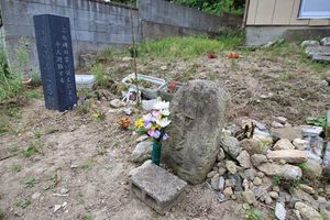
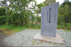
Gallery
Scientific interest
The analysis of the tsunami warning stones, and, especially, the analysis of publications about them, represent certain scientific interest.
At it is mentioned, the most important information is usually omitted in the publications.
The lack of information about the Tsunami warning stone may have some economical reasons: the developers, who sell the ground below the Tsunami warning stones, or homes, or other constructions, that are built-up near the Ocean, below these stones, may be interested hi hide the information about the tsunami warning stones; both what is written there and where the stones are located.
It should be interesting to found other hypothesis, that explain the same phenomenon in any different way.
References
- ↑ http://iwashun.blog.fc2.com/blog-date-20130328.html 山田湾の北に重茂(おもえ)半島の姉吉(あねよし)地区があり、津波記念碑で有名になりました。 2013-03-28 その到達点に、昨年新たな石碑が建ちました。調査によれば、姉吉の津波溯上高は40.4メートル。従来の38.2メートルの更新であり、至上最高記録となりました。(2013年3月19日撮影) 2013年03月28日|いわて旬華愁凍
- ↑ https://www.smithsonianmag.com/smart-news/century-old-warnings-against-tsunamis-dot-japans-coastline-180956448/ Danny Lewis. These Century-Old Stone “Tsunami Stones” Dot Japan’s Coastline. “Remember the calamity of the great tsunamis. Do not build any homes below this point.” AUGUST 31, 2015. At the edge of Aneyoshi, a small village on Japan’s northeastern coast, a 10-foot-tall stone tablet stands, carved with a dire warning to locals. "High dwellings are the peace and harmony of our descendants," the rock slab says. "Remember the calamity of the great tsunamis. Do not build any homes below this point."// While the Aneyoshi tablet might be the most straightforward, so-called “tsunami stones” dot Japan’s coastline, warning the carvers’ descendants to seek high ground after earthquakes in case they foreshadow destructive waves. The stones vary in degrees of repair, with most dating back to around 1896, when two deadly tsunamis killed about 22,000 people, Martin Fackler writes for The New York Times. //
- ↑ http://www.megalithic.co.uk/article.php?sid=34249 The new tsunami memorial tablets - Modern Stone Circle / Monolith in Japan in Honshū. Submitted by Aska on Sunday, 20 September 2015 Page Views: 4105 Modern SitesSite Name: The new tsunami memorial tablets Alternative Name: 津波記憶石. Modern standing stones in Honshū. After the 2011 tsunami disaster which destroyed 40% of the tsunami warning stone tablets on the Pacific coastline, the Japanese guild of stone masons decided to build new 500 tablets designed in a modern style. ..
- ↑ http://www.megalithic.co.uk/article.php?sid=37949 Aska. on Friday, Site Name: Tsunami stone (in Attari) Alternative Name: 合足の津波石 Country: Japan Region: Honshū Type: Natural Stone / Erratic / Other Natural Feature Nearest Town: Ōfunato (Iwate pref.) Nearest Village: Akasakichō-Attari 赤崎& 18 September 2015. Village: Akasakichō-Attari 赤崎& Latitude: 39.031630N Longitude: 141.765720E Condition: 5 Ambience: 4 Access: 2 Accuracy: 5
2011.04.14. http://www.youtube.com/watch?v=qkLqVr_Qk_w sunami110311 on Mar 14, 2011 畑村洋太郎『だから失敗は起こる』第4回 知るを楽しむ「この人この世界。」(2006年放送)
2011.oo.oo. http://tamutamu2011.kuronowish.com/kokoyorisitani.htm 此処より下に家を建てるな. (2011) 高き住居は児孫(じそん=子と孫。子孫)の和楽(わらく=互いにうちとけて楽しむこと) / 想(おも)へ惨禍(さんか=天災・人災などによる、むごたらしくいたましい災難)の大津浪(おおつなみ) /此処(ここ)より下に家を建てるな / 明治二十九年にも、昭和八年にも津浪は此処まで来て / 部落は全滅し、生存者、僅かに前に2人後に4人のみ / 幾歳(いくとし)経るとも要心あれ」」
2011.02.30. http://www.yomiuri.co.jp/national/news/20110329-OYT1T00888.htm 高き住居は児孫 の和楽 想 へ惨禍の大津浪 おおつなみ. (Yomiuri Shimbun, March 30, 22:07 min, 2011.
2011.04.20. https://www.nytimes.com/2011/04/21/world/asia/21stones.html MARTIN FACKLER. Tsunami Warnings, Written in Stone. APRIL 20, 2011.
2017.02.25. http://www.bousai.go.jp/kaigirep/hakusho/h27/honbun/1b_1s_01_05.html 1-5 災害教訓の伝承. 岩手県宮古市重茂姉吉地区では、昭和三陸地震(昭和8年)の津波被害の教訓を刻んだ石碑(大津波記念碑)が建てられており、「此処より下に家を建てるな」との文字が刻まれている。この石碑より高い場所に住居を構えていた住民は、東日本大震災の津波による建物被害を受けなかったことが示すように、過去の災害の教訓・伝承を次世代に受け継いでいくことは、災害被害を軽減する上で重要である。 .. (2017.02.25)
https://ja.wikipedia.org/wiki/大津浪記念碑 姉吉集落にある昭和8年大津波記念碑
Keywords
Fukushima disaster, History, Japan, Never again, Tsunami, Tsunami warning stone,

