Difference between revisions of "File:AvachinskayaGarbage1.jpg"
Jump to navigation
Jump to search
| Line 1: | Line 1: | ||
| + | |||
| + | Map <ref> |
||
| + | https://satellites.pro/Russia_map#52.955588,158.682311,19 |
||
| + | </ref> |
||
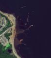
| + | of garbage (sank military ships) at Avachinakaya Guba, buhta Yuznaya. |
||
| + | |||
| + | Coordinates: |
||
| + | |||
| + | 52.95559,158.68231 |
||
| + | |||
| + | ==References== |
||
| + | <references/> |
||
| + | |||
| + | |||
| + | [[Category:2020.10.01.Kamchatka disaster]] |
||
| + | [[Category:Collapse of RF]] |
||
| + | [[Category:Corruption]] |
||
| + | [[Category:Kamchatka]] |
||
| + | [[Category:Map]] |
||
| + | [[Category:Pahanat]] |
||
| + | [[Category:Russia]] |
||
Revision as of 21:15, 12 October 2020
Map [1] of garbage (sank military ships) at Avachinakaya Guba, buhta Yuznaya.
Coordinates:
52.95559,158.68231
References
File history
Click on a date/time to view the file as it appeared at that time.
| Date/Time | Thumbnail | Dimensions | User | Comment | |
|---|---|---|---|---|---|
| current | 09:04, 12 October 2020 |  | 851 × 970 (68 KB) | T (talk | contribs) |
You cannot overwrite this file.
File usage
The following 3 pages use this file: