Difference between revisions of "File:RoskomnadzorMap.png"
Jump to navigation
Jump to search
| Line 1: | Line 1: | ||
| + | Map <ref> |
||
| + | https://www.google.com/maps/@55.7520178,37.6302532,521m/data=!3m1!1e3?hl=en |
||
| + | </ref> |
||
| + | of [[Roskomnadzor]], 2020. |
||
| + | |||
| + | Address: |
||
| + | |||
| + | Kitaygorodskiy Proyezd, 7, стр. 2, Moscow, Russia, 109074 |
||
| + | |||
| + | Китайгородский пр-д, 7, стр. 2, Москва, 109074 |
||
| + | |||
| + | Coordinates: |
||
| + | 55.75160, 37.63654 |
||
| + | |||
| + | ==References== |
||
| + | <references/> |
||
| + | |||
| + | [[Category:Back in the USSR]] |
||
| + | [[Category:Censorship]] |
||
| + | [[Category:Corruption]] |
||
| + | [[Category:Fascism]] |
||
| + | [[Category:Map]] |
||
| + | [[Category:Pahanat]] |
||
| + | [[Category:Roskomnadzor]] |
||
| + | [[Category:Russia]] |
||
Latest revision as of 13:26, 16 October 2020
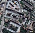
Map [1] of Roskomnadzor, 2020.
Address:
Kitaygorodskiy Proyezd, 7, стр. 2, Moscow, Russia, 109074
Китайгородский пр-д, 7, стр. 2, Москва, 109074
Coordinates: 55.75160, 37.63654
References
File history
Click on a date/time to view the file as it appeared at that time.
| Date/Time | Thumbnail | Dimensions | User | Comment | |
|---|---|---|---|---|---|
| current | 13:25, 16 October 2020 |  | 1,180 × 1,123 (1.8 MB) | T (talk | contribs) |
You cannot overwrite this file.
File usage
The following page uses this file: