Search results
Create the page "Satellite" on this wiki! See also the search results found.
File:MargoBridge.jpg ...own (id est, South), close to another railroad which is also seen from the satellite (at least for year 2010).(1,184 × 822 (69 KB)) - 20:42, 10 September 2013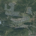
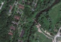
File:Sagra.jpg Satellite view of the village [[Sagra]], Sverdlovskaya oblast, Russia, famous for the [[Category:Satellite view]](1,647 × 1,657 (243 KB)) - 09:39, 21 June 2013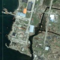
File:Shikotango.jpg Satellite view of the central part of island Shikotan with the structures that look l [[Category:Satellite view]](762 × 757 (175 KB)) - 09:38, 21 June 2013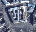
File:Lubianka2013aug.jpg Source: Google satellite service(2,076 × 1,868 (828 KB)) - 08:42, 1 December 2018
File:CosmicForecast01.jpg SATELLITE IN SPACE ...from sunlight unfiltered by atmosphere, look out on a 1929 conception of a satellite.(2,420 × 3,220 (3.19 MB)) - 16:26, 5 January 2024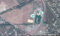
File:GudermesMap.jpg Satellite view at Gudermessky District, Chechnya, Russia 43.35456, 46.09120.(1,829 × 1,120 (587 KB)) - 08:37, 1 December 2018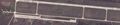
File:Kerch2014.04.10.jpg ...Kerch peninsula, from Berdiansk and from Mariupol), with warplanes there, satellite view by Google.(3,148 × 657 (725 KB)) - 08:39, 1 December 2018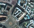
File:Lubianka2014.jpg Satellite view of [[Lubianka]] (Main office of the Russian [[KGB]]), satellite view by [[Category:Satellite]](1,260 × 1,032 (469 KB)) - 08:42, 1 December 2018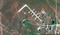
File:Map51.04698,59.85672vh.jpg ...erceptor squadrons and an ICBM base (which has been adapted for commercial satellite launches).(1,846 × 1,096 (770 KB)) - 08:42, 1 December 2018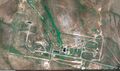
File:Map51.09307 59.84402vh.jpg ...erceptor squadrons and an ICBM base (which has been adapted for commercial satellite launches).(1,847 × 1,098 (837 KB)) - 08:42, 1 December 2018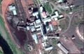
File:ShahtaSevernayaGo.jpg [[Shahta Severnaya]], Satellite view by Google, https://www.google.com/maps/place/67%C2%B035'14.1%22N+64%C2(1,675 × 1,091 (389 KB)) - 08:51, 1 December 2018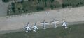
File:Yeysk2014.04.10.jpg Warcrafts at Yeysk, seen from satellite, state for 2014.04.10.(1,786 × 823 (353 KB)) - 08:57, 1 December 2018
File:Nyonoksa.jpg.gif Satellite image from Google Earth showing the Nyonoksa naval missile testing facility(1,000 × 559 (278 KB)) - 09:38, 13 August 2019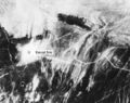
File:LopNor700c15.jpg ...ur days after the test of "596". Image taken by a KH-4 Corona intelligence satellite. Satellite image courtesy John Pike at the Federation of American Scientists, see the(700 × 553 (81 KB)) - 07:16, 25 May 2020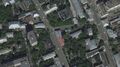
File:AssoGBsat.jpg Satellite view <ref>(1,831 × 1,022 (489 KB)) - 05:28, 27 May 2020
File:Ru Losharik Cutaway940.jpg ...its namesake, Losharik consists of a series of joined spheres. Analysis of satellite imagery of her in dry dock at Severomorsk confirms this, and allows us to s(940 × 548 (111 KB)) - 10:09, 13 June 2020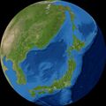
File:Japan2459014.6416.jpg View of [[Japan]] from [[satellite]] [[NOAA ETOPO2]], [[Category:Satellite]](777 × 776 (133 KB)) - 15:18, 15 June 2020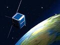
File:Yubileiny39419.jpeg Satellite [[Yublileiny]] by [[Dmitry Sudakov]], 2010 ...008. The engine, which operates both autonomously and remotely, allows the satellite to move from one orbit to another.(200 × 150 (8 KB)) - 23:26, 22 June 2020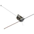
File:1346944438 ka ubileiniy2 b.png Satellite [[Yubileiny]] with [[inertioid]] [[Gravitsapa]] on board(350 × 350 (14 KB)) - 17:53, 5 July 2020
File:PlaceFig01.jpg Principle of propulsion of the Russian satellite First picture, basic principle of propulsion of the Russian satellite [[Yubilleiny]] <ref>(1,013 × 456 (163 KB)) - 04:48, 10 October 2020


