Search results
Create the page "Aerial" on this wiki! See also the search results found.
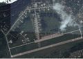
File:Vh41486airstrip.jpg Aerial view of the airstrip of [[Vh41486]] at Tver, Russia (migalovo)(1,538 × 1,090 (295 KB)) - 08:55, 1 December 2018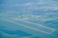
File:Vh69806.430x280.jpg [[vh69806]] ([[вч 69806]]), aerial view(430 × 280 (72 KB)) - 08:55, 1 December 2018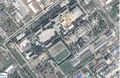
File:Vh73612map0.jpg [[vh73612]] ([[вч 73612]]), aerial view by google.(1,667 × 1,090 (723 KB)) - 08:55, 1 December 2018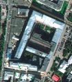
File:Znamenka19.jpg Aerial view of the Russian ministry of Defence, Znamenka 18.(796 × 911 (134 KB)) - 08:57, 1 December 2018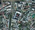
File:Znamenka19Large3.jpg Moscow, Znamenka 19 aerial view.(1,216 × 1,037 (531 KB)) - 08:57, 1 December 2018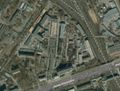
File:NiiohtMap.jpeg Aerial view of [[Niioht]], Moscow.(1,262 × 958 (466 KB)) - 19:10, 23 December 2018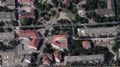
File:KenigsbergSudMa.jpg [[Центральный райсуд Калининграда]] ), aerial view from its West side.(1,917 × 1,077 (109 KB)) - 17:10, 18 October 2019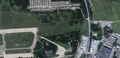
File:Katyn2map.jpg Aerial view of place of the [[Katyn-2]] catastrophe.(1,544 × 746 (76 KB)) - 21:02, 20 October 2019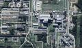
File:BeloyarkaMap0zoomin.jpg ...С]] ([[Белоярка]], [[Beloyarsk Nuclear plant]], [[Beloyarka]] ), aerial view from the North side.(1,920 × 1,139 (337 KB)) - 01:56, 7 December 2019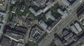
File:FSOUBTCsate.jpg Aerial view <ref>(1,831 × 1,022 (520 KB)) - 23:23, 26 May 2020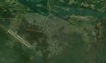
File:KamchatkaMissileBase.jpg Aerial view <ref>https://www.google.com/maps/place/56%C2%B018'31.2%22N+160%C2%B048(1,820 × 1,076 (375 KB)) - 16:30, 20 October 2020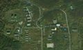
File:KamchatkaTwoCisterns.jpg Aerial view <ref>https://satellites.pro/Russia_map#56.308173,160.846103,19(1,743 × 1,062 (298 KB)) - 16:33, 20 October 2020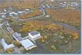
File:I0395rp.jpg at the aerial view of the [[Kamchatka Missile base]](916 × 615 (122 KB)) - 19:33, 20 October 2020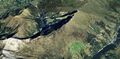
File:DorfliAerial02.jpg Aerial view of mounts above [[Dorfli]](1,917 × 947 (290 KB)) - 16:53, 14 January 2021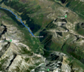
File:AerialDorfliSertig8.png [[Category:Aerial]](1,187 × 1,017 (371 KB)) - 12:57, 15 January 2021
File:TanzawaNEtrailheadMap.jpg [[Aerial view]] on the trailhead of the way to Tanzawa from Notrh-East, from road 70 [[Category:Aerial view]](1,921 × 1,101 (973 KB)) - 21:00, 25 January 2021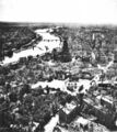
File:Frankfurt am Main 1945.jpg Description: Ruins of Frankfurt am Main after WW II, aerial photograph of USAF(2,282 × 2,560 (1.7 MB)) - 01:53, 5 March 2021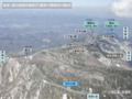
File:KibigaraYamaMap01.png Aerial view on mount Kibigara and vicinity.(1,261 × 946 (1.54 MB)) - 15:33, 4 August 2021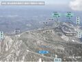
File:KibigaraYamaMap01.jpg Aerial view on mount [[Kibigara]] and vicinity.(1,261 × 946 (272 KB)) - 14:19, 6 August 2021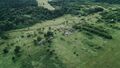
File:Uvarovo airview09.jpg [[Category:Aerial view]](1,200 × 680 (271 KB)) - 00:03, 25 August 2021


