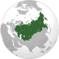
File:Union of Soviet Socialist Republics orthographic projection.png
Revision as of 08:55, 1 December 2018 by Maintenance script (talk | contribs)

Size of this preview: 600 × 600 pixels. Other resolutions: 240 × 240 pixels | 1,024 × 1,024 pixels.
Original file (1,024 × 1,024 pixels, file size: 343 KB, MIME type: image/png)
Map of the USSR by Wikimedia, [1]
References
- ↑ https://commons.wikimedia.org/wiki/File:Union_of_Soviet_Socialist_Republics_(orthographic_projection).svg The map has been created with the Generic Mapping Tools: http://gmt.soest.hawaii.edu/ using one or more of these public domain datasets for the relief: ETOPO2 (topography/bathymetry): http://www.ngdc.noaa.gov/mgg/global/global.html GLOBE (topography): http://www.ngdc.noaa.gov/mgg/topo/gltiles.html SRTM (topography): http://www2.jpl.nasa.gov/srtm/ 30 March 2009.
File history
Click on a date/time to view the file as it appeared at that time.
| Date/Time | Thumbnail | Dimensions | User | Comment | |
|---|---|---|---|---|---|
| current | 06:14, 1 December 2018 |  | 1,024 × 1,024 (343 KB) | Maintenance script (talk | contribs) | Importing image file |
You cannot overwrite this file.
File usage
The following page uses this file: