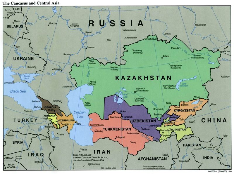
File:Caucasus central asia political map 2000.jpg
Revision as of 14:51, 18 January 2022 by T (talk | contribs) (Caucasus and Soviet Central Asia at year 2000. Map by Wikimedia <ref> https://commons.wikimedia.org/wiki/File:Caucasus_central_asia_political_map_2000.jpg Description Political Map of the Caucasus and Central Asia Source http://ftp.lib.utex...)

Size of this preview: 800 × 596 pixels. Other resolutions: 320 × 239 pixels | 1,390 × 1,036 pixels.
Original file (1,390 × 1,036 pixels, file size: 164 KB, MIME type: image/jpeg)
Summary
Caucasus and Soviet Central Asia at year 2000.
Map by Wikimedia [1]
Original filename:
https://upload.wikimedia.org/wikipedia/commons/7/73/Caucasus_central_asia_political_map_2000.jpg
References
- ↑ https://commons.wikimedia.org/wiki/File:Caucasus_central_asia_political_map_2000.jpg Description Political Map of the Caucasus and Central Asia Source http://ftp.lib.utexas.edu/maps/kazakhstan.html (CIA-Scans) Author CIA .. Public domain This work is in the public domain in the United States
File history
Click on a date/time to view the file as it appeared at that time.
| Date/Time | Thumbnail | Dimensions | User | Comment | |
|---|---|---|---|---|---|
| current | 14:51, 18 January 2022 |  | 1,390 × 1,036 (164 KB) | T (talk | contribs) | Caucasus and Soviet Central Asia at year 2000. Map by Wikimedia <ref> https://commons.wikimedia.org/wiki/File:Caucasus_central_asia_political_map_2000.jpg Description Political Map of the Caucasus and Central Asia Source http://ftp.lib.utex... |
You cannot overwrite this file.
File usage
The following 4 pages use this file: