File:ChazhmaMapWiki.jpg
Revision as of 07:09, 30 May 2022 by T (talk | contribs) (1985.08.10.Ядерная катастрофа Чажмы, map: Vladivostok, 1. place of the explosion of the submarine 2. Place of sinking of the wreckage Nahodka Screenshot of the Image by Wikipedia <ref> https://ru.wikipedia.org/w...)
ChazhmaMapWiki.jpg (442 × 367 pixels, file size: 26 KB, MIME type: image/jpeg)
Summary
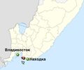
1985.08.10.Ядерная катастрофа Чажмы, map:
1. place of the explosion of the submarine
2. Place of sinking of the wreckage
Screenshot of the Image by Wikipedia [1]
Original description
Место аварии на карте Приморского края и крупнейшие города.
1 — место аварии,
2 — место хранения аварийной лодки
References
- ↑ https://ru.wikipedia.org/wiki/Радиационная_авария_в_бухте_Чажма Радиационная авария в бухте Чажма — авария ядерной энергетической установки на атомной подводной лодке Советского Тихоокеанского флота, повлёкшая за собой радиоактивное заражение окружающей среды, гибель одиннадцати и облучение сотен людей. // Место аварии на карте Приморского края и крупнейшие города. 1 — место аварии, 2 — место хранения аварийной лодки
File history
Click on a date/time to view the file as it appeared at that time.
| Date/Time | Thumbnail | Dimensions | User | Comment | |
|---|---|---|---|---|---|
| current | 07:09, 30 May 2022 |  | 442 × 367 (26 KB) | T (talk | contribs) | 1985.08.10.Ядерная катастрофа Чажмы, map: Vladivostok, 1. place of the explosion of the submarine 2. Place of sinking of the wreckage Nahodka Screenshot of the Image by Wikipedia <ref> https://ru.wikipedia.org/w... |
You cannot overwrite this file.
File usage
The following page uses this file:
