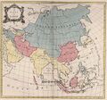
File:1754TartariaMap.jpg
Jump to navigation
Jump to search


Size of this preview: 644 × 599 pixels. Other resolutions: 258 × 240 pixels | 706 × 657 pixels.
Original file (706 × 657 pixels, file size: 140 KB, MIME type: image/jpeg)
Map of Tartaria at 1154 by Wikimedia. https://commons.wikimedia.org/wiki/File:1754_Tartaria_map.jpg
Original filename: https://upload.wikimedia.org/wikipedia/commons/8/8c/1754_Tartaria_map.jpg
Description
The Empire of Tartary in 1754
English: Tartary, Persia, India and China
Date 9 March 2019, 16:38:39
Source Le Carte De Asie 1754
Author Palairet, Jean
References
File history
Click on a date/time to view the file as it appeared at that time.
| Date/Time | Thumbnail | Dimensions | User | Comment | |
|---|---|---|---|---|---|
| current | 01:08, 17 December 2019 |  | 706 × 657 (140 KB) | T (talk | contribs) |
You cannot overwrite this file.