File:Marianatrenchmap.jpg

Original file (756 × 984 pixels, file size: 187 KB, MIME type: image/jpeg)
Summary
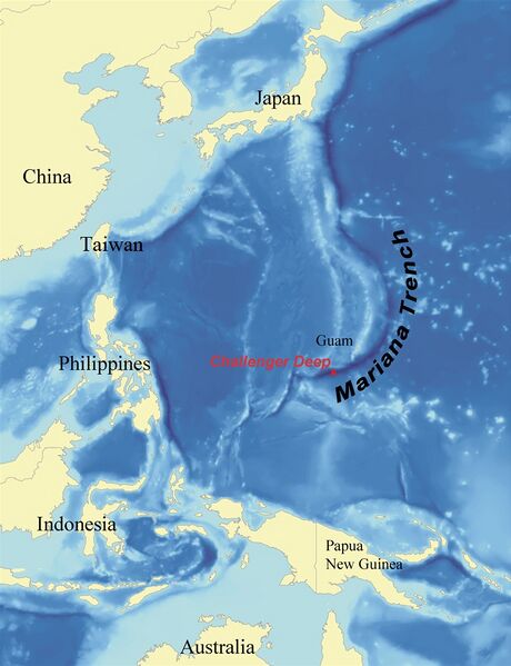
Nap or the Marianа trench
Image by Wikimedia [1]
The honest use is assumed, the source should be attributed.
Original filename: https://upload.wikimedia.org/wikipedia/commons/1/1b/Marianatrenchmap.png
Description
https://en.wikipedia.org/wiki/File:Marianatrenchmap.png
English: Map showing the location of the Mariana Trench, designed as a replacement for en:Image:Mariana_trench_location.jpg.
Français : Carte montrant la position de la fosse des Mariannes.
Latina: Haec charta locum Fossae Marianae demonstrat.
Date 2 August 2007
Source self-made using data from NOAA[dead link].
Author wallace
I, Kmusser, the copyright holder of this work, hereby publishes it under the following licenses:
GNU head Permission is granted to copy, distribute and/or modify this document under the terms of the GNU Free Documentation License, Version 1.2 or any later version published by the Free Software Foundation; with no Invariant Sections, no Front-Cover Texts, and no Back-Cover Texts. A copy of the license is included in the section entitled GNU Free Documentation License.
References
- ↑ https://en.wikipedia.org/wiki/File:Marianatrenchmap.png English: Map showing the location of the Mariana Trench, designed as a replacement for en:Image:Mariana_trench_location.jpg. Français : Carte montrant la position de la fosse des Mariannes. Latina: Haec charta locum Fossae Marianae demonstrat. Date 2 August 2007 Source self-made using data from NOAA[dead link]. Author wallace I, Kmusser, the copyright holder of this work, hereby publishes it under the following licenses: GNU head Permission is granted to copy, distribute and/or modify this document under the terms of the GNU Free Documentation License, Version 1.2 or any later version published by the Free Software Foundation; with no Invariant Sections, no Front-Cover Texts, and no Back-Cover Texts. A copy of the license is included in the section entitled GNU Free Documentation License.
File history
Click on a date/time to view the file as it appeared at that time.
| Date/Time | Thumbnail | Dimensions | User | Comment | |
|---|---|---|---|---|---|
| current | 01:49, 29 October 2023 |  | 756 × 984 (187 KB) | T (talk | contribs) | {{oP}} Nap or the Marianа trench Image by Wikimedia <ref> https://en.wikipedia.org/wiki/File:Marianatrenchmap.png English: Map showing the location of the Mariana Trench, designed as a replacement for en:Image:Mariana_trench_location.jpg. Fr... |
You cannot overwrite this file.
File usage
The following page uses this file: