File:Vh3642map20.jpg

Original file (1,800 × 948 pixels, file size: 256 KB, MIME type: image/jpeg)
Summary
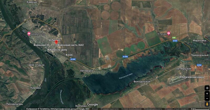
Vh3642 (Вч 3642, red mark) and the Marinka Airbaze (Авиабаза Маринka) at the Google map
Coordinates:
48.7045,43.4706 Strategic bridge
48.6952,43.4967 River port
48.6894,43.5386 Gas station
48.6830,43.5347 Военкомат (Октябрьская ул., 232, Калач-на-Дону)
48.6829,43.5510 Вч 3642, main gate
48.6769,43.5351 Fuel factory
48.6703,43.5712 Gas station
48.6413,43.7940 Marinovka Airbase (Авиабаза Мариновка)
48.6388,43.5981 шлюзовые ворота судоходного канала
48.6388,43.6004 шлюзовые ворота судоходного канала
48.6330,43.6068 strategic dam
References
Keywords
«[[]]», «Designate Russia as state sponsor of terrorism», «Designate Russia as terrorist state», «Fascism», «Marinovka Airbase», «Moscovia», «New World Order», «Putin world war», «Russian invasion into Ukraine», «Transfer of hostilities to aggressor territory», «Vh3642», «War crime»,
«А нас то за что», «Авиабаза Мариновка», «Аннексия Крыма», «[[]]», «Будапештский меморандум», «Вертикаль власти», «Вч 3642», «Легитимная цель», «Московия», «Мы попадём в рай а они сдохнут», «Новый Мировой Порядок», «[[]]», «Паханат», «Перенос боевых действий на территорию страны агрессора», «[[]]», «Путинская мировая война», «Российское вторжение в Украину», «Санитарная зона», «Спецоперация», «Ср.353 УК РФ»,
File history
Click on a date/time to view the file as it appeared at that time.
| Date/Time | Thumbnail | Dimensions | User | Comment | |
|---|---|---|---|---|---|
| current | 22:31, 23 August 2024 |  | 1,800 × 948 (256 KB) | T (talk | contribs) | {{oq|Vh3642map20.jpg|}} Vh3642 (Вч 3642, red mark) and the Marinka Airbaze (Авиабаза Маринka) at the Google map Coordinates: <poem> 48.7045,43.4706 Strategic bridge 48.6952,43.4967 River port 48.6894,43.5386 Gas station... |
You cannot overwrite this file.
File usage
The following page uses this file: