File:2015.07.26.CrashMap.png

Size of this preview: 722 × 600 pixels. Other resolutions: 289 × 240 pixels | 903 × 750 pixels.
Original file (903 × 750 pixels, file size: 929 KB, MIME type: image/png)
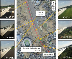
Map of the 2015.07.26.Crash [1] page 60, Figure 2.16.5.4 Estimated Flight Route.
References
- ↑ 2017.07.18. https://www.mlit.go.jp/jtsb/eng-air_report/JA4060.pdf AA2017-4AIRCRAFT ACCIDENTINVESTIGATION REPORTPRIVATELY OWNEDJ A 4 0 6 0 July 18, 2017 The objective of the investigation conducted by the Japan Transport Safety Board in accordance with the Act for Establishment of the Japan Transport Safety Board and with Annex 13 to the Convention on International Civil Aviation is to determine the causes of an accident and damage incidental to such an accident,thereby preventing future accidents and reducing damage. It is not the purpose of the investigation to apportion blame or liability.Kazuhiro NakahashiChairmanJapan Transport Safety BoardNote:This report is a translation of the Japanese original investigation report. The text in Japanese shall prevail in the interpretation of the report.// CRASH AFTER TAKEOFFPRIVATELYOWNEDPIPER PA-46-350P, JA4060CHOFU CITY, TOKYO METROPOLITAN, JAPANAT AROUND10:58 JST, JULY 26, 2015July 7, 2017 Adopted by the Japan Transport Safety Board Chairman Kazuhiro Nakahashi// MemberToru Miyashita// MemberToshiyuki// Ishikawa MemberYuichi// Marui MemberKeiji TanakaMemberMiwa Nakanishi ..
File history
Click on a date/time to view the file as it appeared at that time.
| Date/Time | Thumbnail | Dimensions | User | Comment | |
|---|---|---|---|---|---|
| current | 00:09, 4 September 2020 | | 903 × 750 (929 KB) | T (talk | contribs) |
- You cannot overwrite this file.
File usage
The following page links to this file: