Difference between revisions of "File:Samoyedic map XVII-XX.png"
(Importing image file) |
|||
| Line 1: | Line 1: | ||
| + | Территория непризнанной страны [[Самоди]], населенной самодийцами. |
||
| − | Importing image file |
||
| + | |||
| + | Original filename: |
||
| + | https://upload.wikimedia.org/wikipedia/commons/8/81/Samoyedic_map_XVII-XX.png |
||
| + | |||
| + | ==Description== |
||
| + | |||
| + | https://commons.wikimedia.org/wiki/File:Samoyedic_map_XVII-XX.png |
||
| + | |||
| + | <poem> |
||
| + | English: The map of distribution of Samoyedic languages (red) in the XVII century (approximate; hatching) and in the end of XX century (continuous background). |
||
| + | Русский: Карта распространения самодийских языков (красный) в XVII веке (приблизительно; штриховка) и в конце XX века (сплошной фон). |
||
| + | Date 3 January 2009 |
||
| + | Source background: File:Map of Russian subjects recent.png; |
||
| + | data: |
||
| + | Pakendorf, Brigitte (2007) "Chapter 1 : Introduction" in Contact in the prehistory of the Sakha (Yakuts): Linguistic and genetic perspectives. ISBN: 978-90-78328-42-1. |
||
| + | INSROP Working Paper No. 90 in 1997. Detailed maps: Indigenous peoples of northern part of Russian Federation |
||
| + | Author Background map by user:fremantleboy, language map by Minami Himemiya |
||
| + | Permission |
||
| + | (Reusing this file) |
||
| + | |||
| + | This file is licensed under the Creative Commons Attribution 2.5 Generic license. |
||
| + | You are free: |
||
| + | to share – to copy, distribute and transmit the work |
||
| + | to remix – to adapt the work |
||
| + | Under the following conditions: |
||
| + | attribution – You must attribute the work in the manner specified by the author or licensor (but not in any way that suggests that they endorse you or your use of the work). |
||
| + | </poem> |
||
| + | |||
| + | ==References== |
||
| + | <references/> |
||
| + | |||
| + | [[Category:Genocide]] |
||
| + | [[Category:Kuzkina mat]] |
||
| + | [[Category:Map]] |
||
| + | [[Category:Samodi]] |
||
| + | [[Category:Russia]] |
||
| + | [[Category:USSR]] |
||
| + | [[Category:Wikimedia]] |
||
Latest revision as of 08:50, 1 December 2018
Территория непризнанной страны Самоди, населенной самодийцами.
Original filename: https://upload.wikimedia.org/wikipedia/commons/8/81/Samoyedic_map_XVII-XX.png
Description
https://commons.wikimedia.org/wiki/File:Samoyedic_map_XVII-XX.png
English: The map of distribution of Samoyedic languages (red) in the XVII century (approximate; hatching) and in the end of XX century (continuous background).
Русский: Карта распространения самодийских языков (красный) в XVII веке (приблизительно; штриховка) и в конце XX века (сплошной фон).
Date 3 January 2009
Source background: File:Map of Russian subjects recent.png;
data:
Pakendorf, Brigitte (2007) "Chapter 1 : Introduction" in Contact in the prehistory of the Sakha (Yakuts): Linguistic and genetic perspectives. ISBN: 978-90-78328-42-1.
INSROP Working Paper No. 90 in 1997. Detailed maps: Indigenous peoples of northern part of Russian Federation
Author Background map by user:fremantleboy, language map by Minami Himemiya
Permission
(Reusing this file)
This file is licensed under the Creative Commons Attribution 2.5 Generic license.
You are free:
to share – to copy, distribute and transmit the work
to remix – to adapt the work
Under the following conditions:
attribution – You must attribute the work in the manner specified by the author or licensor (but not in any way that suggests that they endorse you or your use of the work).
References
File history
Click on a date/time to view the file as it appeared at that time.
| Date/Time | Thumbnail | Dimensions | User | Comment | |
|---|---|---|---|---|---|
| current | 06:14, 1 December 2018 | 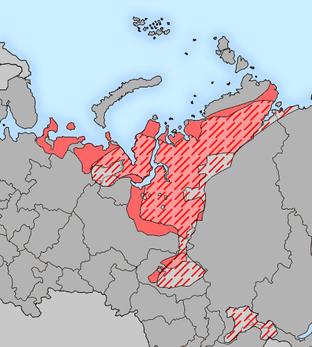 | 450 × 500 (36 KB) | Maintenance script (talk | contribs) | Importing image file |
- You cannot overwrite this file.
File usage
The following page links to this file: