Search results
Create the page "Google" on this wiki! See also the search results found.
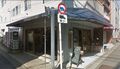
File:YamazakiGoogle.jpg Google view of the [[Yamazaki Boots]], the shoe repair shop. Image by google <ref>(1,882 × 1,079 (392 KB)) - 04:53, 25 December 2020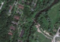
File:MargoBridge.jpg http://maps.google.com/?ie=UTF8&ll=55.8070,37.0868&z=18 Google map(1,184 × 822 (69 KB)) - 20:42, 10 September 2013
File:SagraGmap.jpg http://maps.google.com/maps?q=57.0319,60.3&ll=59.977005,51.240234&spn=29.51006,85.693359&z=4 Copyright of this image belongs to Google. The honest use is assumed.(1,200 × 915 (55 KB)) - 09:39, 21 June 2013
File:TwinsChofuHotel.jpg Picture of the Twins Chofu Hotel suggested by the google.map ; [[Category:Google]](1,827 × 962 (147 KB)) - 09:43, 21 June 2013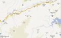
File:Yakiyama01map.jpg Map of Yakiyama mount (35.539 N,139.164 E) and vicinity by Google, http://maps.google.com/?ll=35.591017,139.196091&spn=0.050952,0.070381&t=m&z=13&vpsrc=6(1,895 × 1,190 (234 KB)) - 09:40, 21 June 2013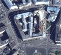
File:Lubianka2013aug.jpg Source: Google satellite service(2,076 × 1,868 (828 KB)) - 08:42, 1 December 2018
File:Reshety.jpg Snapshot from the Google [[map]], https://maps.google.com/maps?&ll=56.855,60.241 The honest use is assumed, attribute the GOOGLE at the reproduction.(1,909 × 1,839 (1.29 MB)) - 11:02, 27 August 2013
File:MargoBridge3.jpg http://maps.google.com/?ie=UTF8&ll=55.8070,37.0868&z=18 Google map, 2013 [[Category:Google maps]](1,874 × 2,039 (1.66 MB)) - 21:18, 10 September 2013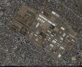
File:35.58194 139.37917.jpg [[Sagami military base]], Google map at(1,346 × 1,102 (607 KB)) - 08:27, 1 December 2018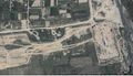
File:42.2053 43.9816.jpg Google map at 42.2053_43.9816(1,644 × 945 (605 KB)) - 08:27, 1 December 2018
File:42.22766 43.9746.jpg Google map at 42.22766_43.9746(1,405 × 857 (398 KB)) - 08:27, 1 December 2018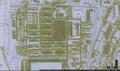
File:42.2367 43.9587.jpg Google map at 42.2367,43.9587 , North part of [[vh66431]] ([[Вч 66431]] )(1,625 × 956 (407 KB)) - 08:27, 1 December 2018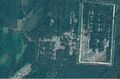
File:53.4663 33.9445.jpg Google map at [[53.4663,33.9445]](1,659 × 1,094 (923 KB)) - 08:28, 1 December 2018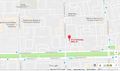
File:55.80426 37.81266.jpg Google map at 55.80426_37.81266 https://www.google.com/maps/place/55°48'15.3%22N+37°48'45.6%22E/@55.804266,37.8104743,17z/da(1,482 × 873 (179 KB)) - 08:28, 1 December 2018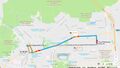
File:AbbazovMap.jpg Google driving direction between points https://www.google.com/maps/dir/55.802245,37.707104/'55.80426,37.81266'/@55.8145838,37.7479516(1,518 × 866 (252 KB)) - 08:28, 1 December 2018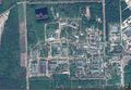
File:AvangardSarovMap.jpg (1,599 × 1,103 (906 KB)) - 08:30, 1 December 2018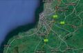
File:AyrAllowayMap.jpg Google map of vicinity of bridge across river Doon (B7024 Ayr KA7, UK, coordinates(1,285 × 815 (199 KB)) - 08:30, 1 December 2018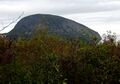
File:Ayu-Dag Mountain.JPG ...4° 20′ 06.46″ E View this and other nearby images on: OpenStreetMap - Google Earth info(2,000 × 1,397 (1.17 MB)) - 08:30, 1 December 2018
File:BalashikhaOktiabrskaya7.jpeg by Google. ...ems to be location of the [[Железнодорожный УИК 580]] by Google maps,(402 × 168 (35 KB)) - 08:30, 1 December 2018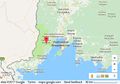
File:BarabashMap0.jpg Google map of vicinity of town Barabash, 43.19234, 131.50865(604 × 425 (86 KB)) - 08:30, 1 December 2018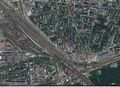
File:BatskihMap.jpg Google map at 55.73932, 37.76328(1,496 × 1,090 (739 KB)) - 08:30, 1 December 2018
File:BatskihZoomOut.jpg Google map at 55.73932, 37.76328 and(1,374 × 1,083 (803 KB)) - 08:30, 1 December 2018
File:Borzoi.jpg Google map of посёлок Борзой(1,555 × 1,099 (638 KB)) - 08:31, 1 December 2018
File:BotMap2.jpg [[Боткинская больница]], google map at 55.7796, 37.55332 https://www.google.com/maps/place/2-y+Botkinskiy+pr-d,+5к17,+Moskva,+Russia,+125284/@55.78054(1,166 × 833 (228 KB)) - 08:31, 1 December 2018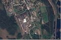
File:ColonyKeygubskaya.jpg Google map at Segezhsky District, Republic of Karelia, Russia, https://www.google.com/maps/dir///@63.7751652,34.2950426,891m/data=!3m1!1e3(1,428 × 953 (525 KB)) - 08:32, 1 December 2018- Error creating thumbnail: File missing
File:Čížov-1.jpg ...5° 52′ 17.79″ E View this and other nearby images on: OpenStreetMap - Google Earth(4,273 × 2,348 (2.4 MB)) - 08:32, 1 December 2018 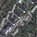
File:DerbyshkiMap.jpg Google map of police office [[Derbyshki]],(834 × 842 (267 KB)) - 08:34, 1 December 2018
File:Dubinski745504 600.jpg (241 × 300 (12 KB)) - 08:34, 1 December 2018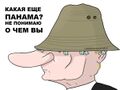
File:E0uo4AKWgmE.jpg [[Panama Pages]] by Google http://www.google.com/url?sa=i&rct=j&q=&esrc=s&source=images&cd=&ved=0ahUKEwj5z931q_nLAhXHI5Q(600 × 450 (32 KB)) - 08:34, 1 December 2018
File:Elkin37869045 403.jpg Well, Google, where to hide our treasure? ...тин-и-премьер-медведев-могли-бы-спросить-google/a-37869681(940 × 529 (60 KB)) - 08:35, 1 December 2018
File:GudermesMap.jpg [[Category:Google]](1,829 × 1,120 (587 KB)) - 08:37, 1 December 2018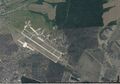
File:HalinoMap.jpg Google map of Halino, [[vh23243]] ([[Вч 23243]]),(1,563 × 1,093 (543 KB)) - 08:37, 1 December 2018
File:HotelSiamozeroMap.jpg Google map of [[Hotel Siamozero]] https://www.google.com/maps/place/Hotel+Syamozero/@61.9072717,33.016101,522m/data=!3m1!1e3!4m5(1,314 × 1,063 (487 KB)) - 08:38, 1 December 2018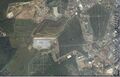
File:HovanCemeteryMap.jpg Google map at 55.60855, 37.44128(1,704 × 1,092 (668 KB)) - 08:38, 1 December 2018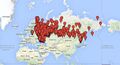
File:Karta-rf.jpg ...интерактивный вариант этой карты https://www.google.com/maps/d/viewer?mid=1a1oXUvWbZY3X5ohseoumaoUILBg и его описани https://www.google.com/maps/d/viewer?mid=1a1oXUvWbZY3X5ohseoumaoUILBg(783 × 421 (134 KB)) - 13:12, 2 September 2023
File:Kerch2014.04.10.jpg ...rom Berdiansk and from Mariupol), with warplanes there, satellite view by Google. https://www.google.com/maps/place/46°03'26.0%22N+38°14'00.0%22E/@46.0572222,38.2333333,2808m(3,148 × 657 (725 KB)) - 08:39, 1 December 2018
File:Kirova24LogunovMap.jpg Google map at 51.52094, 38.03664(1,680 × 1,075 (703 KB)) - 08:40, 1 December 2018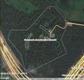
File:KommunarkaMap.jpg Google map of [[kommunarka]] at 55.5792, 37.4558, Soviet [[concentration camp]], u(578 × 548 (138 KB)) - 08:40, 1 December 2018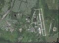
File:KomsomolskNaAmureAir.jpg Google map of the airport of Komsomolsk na Amure(1,499 × 1,086 (628 KB)) - 08:40, 1 December 2018
File:Kondratev F.V.jpg ...ed on OpenStreetMap. View this and other nearby images on: OpenStreetMap - Google Earth(2,448 × 3,264 (1.65 MB)) - 08:40, 1 December 2018
File:Kulakova13.jpg Google map at(1,404 × 815 (362 KB)) - 08:41, 1 December 2018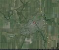
File:KuschevkaMap.jpg [[Category:Google map]](1,263 × 1,068 (370 KB)) - 08:41, 1 December 2018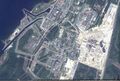
File:Laes2map2.jpg [[ЛАЭС2]], google [[map]](1,641 × 1,103 (736 KB)) - 08:41, 1 December 2018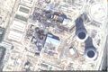
File:Laes2map3.jpg [[ЛАЭС2]], google [[map]](1,651 × 1,101 (637 KB)) - 08:41, 1 December 2018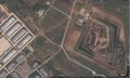
File:Map42.828144,47.09984.jpg Google map at(1,559 × 936 (392 KB)) - 08:42, 1 December 2018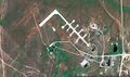
File:Map51.04698,59.85672vh.jpg Google map of the airbase of [[vh93766]] at 51.04698,59.85672(1,846 × 1,096 (770 KB)) - 08:42, 1 December 2018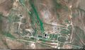
File:Map51.09307 59.84402vh.jpg Google map of the rocket base of [[vh93766]] at 51.09307,59.84402(1,847 × 1,098 (837 KB)) - 08:42, 1 December 2018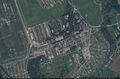
File:Map55.23799 37.96538.jpg Google map at 55.23799,37.96538(1,665 × 1,099 (702 KB)) - 08:42, 1 December 2018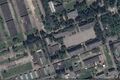
File:Map55.23799 37.96538zoom.jpg Google map at 55.23799,37.96538(1,662 × 1,104 (497 KB)) - 08:42, 1 December 2018
File:Map70brigade.jpg Google map of the [[vh24776]] ([[Вч 24776]]), https://www.google.com/maps/d/viewer?mid=1wMTPdw3TjQO13iyv3Rf4Qx3NyhM&ll=43.430711633643185%2C(689 × 556 (87 KB)) - 08:42, 1 December 2018


