Search results
Create the page "Satellite view" on this wiki! See also the search results found.
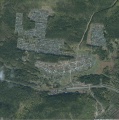
File:Sagra.jpg Satellite view of the village [[Sagra]], Sverdlovskaya oblast, Russia, famous for the hero [[Category:Satellite view]](1,647 × 1,657 (243 KB)) - 09:39, 21 June 2013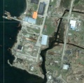
File:Shikotango.jpg [[Category:Satellite view]](762 × 757 (175 KB)) - 09:38, 21 June 2013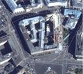
File:Lubianka2013aug.jpg Aerial view of Lubyaka, main office of the [[KGB]], ideologic police of the [[USSR]] an VIew at the approach from the South–West, year 2010.(2,076 × 1,868 (828 KB)) - 08:42, 1 December 2018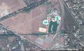
File:GudermesMap.jpg Satellite view at Gudermessky District, Chechnya, Russia 43.35456, 46.09120.(1,829 × 1,120 (587 KB)) - 08:37, 1 December 2018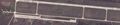
File:Kerch2014.04.10.jpg ...nsula, from Berdiansk and from Mariupol), with warplanes there, satellite view by Google.(3,148 × 657 (725 KB)) - 08:39, 1 December 2018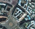
File:Lubianka2014.jpg ...llite view of [[Lubianka]] (Main office of the Russian [[KGB]]), satellite view by [[Category:Satellite]](1,260 × 1,032 (469 KB)) - 08:42, 1 December 2018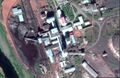
File:ShahtaSevernayaGo.jpg [[Shahta Severnaya]], Satellite view by Google, https://www.google.com/maps/place/67%C2%B035'14.1%22N+64%C2%B004(1,675 × 1,091 (389 KB)) - 08:51, 1 December 2018
File:AssoGBsat.jpg Satellite view <ref>(1,831 × 1,022 (489 KB)) - 05:28, 27 May 2020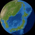
File:Japan2459014.6416.jpg View of [[Japan]] from [[satellite]] [[NOAA ETOPO2]], View from 345 km above 42°1'N 136°24'E(777 × 776 (133 KB)) - 15:18, 15 June 2020
File:MinskL5.jpg Satellite look from East on the Minsk office of [[Centrkurort]] [[Category:View]](740 × 920 (221 KB)) - 13:54, 19 November 2021
File:GUMVDpoNiNovgoSat2.jpg Satellite view <ref> [[Category:Satellite]](1,521 × 1,062 (648 KB)) - 13:06, 25 January 2022
File:Vh75392map1.jpg Satellite view of [[Vh75392]] <ref>(1,919 × 1,000 (655 KB)) - 23:06, 26 March 2022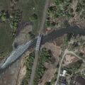
File:RazumnyBridgeSatSE.jpg [[Razumny Bridge]] ([[Разумный мост]]), satellite vies from SE <ref> [[Category:Satellite view]](600 × 600 (131 KB)) - 02:02, 16 April 2022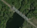
File:NezhegolRailroadBridge400.jpg [[Category:Satellite view]](400 × 300 (37 KB)) - 01:43, 17 April 2022
File:MasyrKuybyshevaCDEKsat.jpg Satellite view <ref name="sat"> [[Category:Satellite]](622 × 539 (111 KB)) - 11:18, 19 April 2022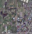
File:Vh06720sat.jpg View on the entry of the [[Vh06720]] ([[Вч 6720]]) <ref> [[Category:Satellite]](983 × 1,065 (482 KB)) - 11:40, 19 April 2022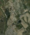
File:Vh51460sat.jpg Satellite view of [[Vh51460]] ([[Вч 51460]]) [[Category:Satellite]](927 × 1,084 (452 KB)) - 08:44, 24 April 2022
File:Vh51460goog2.jpg Google view of [[Vh51460]] ([[Вч 51460]]) [[Category:Satellite]](1,515 × 845 (273 KB)) - 08:46, 24 April 2022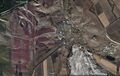
File:BilohorivkaMap1.jpg Satellite view on [[Belohorivka]] by Google(1,693 × 1,079 (323 KB)) - 00:49, 11 May 2022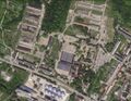
File:Vh90151sat.jpg Satellite view<ref> [[Category:Satellite]](1,200 × 927 (415 KB)) - 09:59, 8 June 2022


