File:Kerch2014.04.10.jpg

Size of this preview: 800 × 167 pixels. Other resolutions: 320 × 67 pixels | 3,148 × 657 pixels.
Original file (3,148 × 657 pixels, file size: 725 KB, MIME type: image/jpeg)
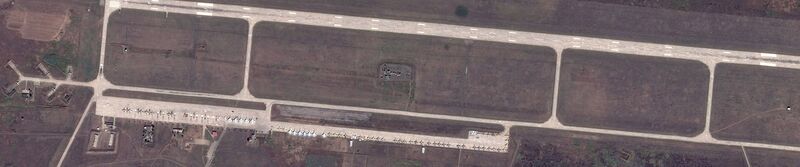
Primorsko-Akhtarskiy rayon, Krasnodarskiy kray, Russia, 46°03'27.0"N 38°13'40.0"E Russian airbase near the Azov sea; 100kn from Ukraine (100 km from the Kerch peninsula, from Berdiansk and from Mariupol), with warplanes there, satellite view by Google. State for 2014.04.10. The honest use is assumed, the source should be attributed. https://www.google.com/maps/place/46°03'26.0%22N+38°14'00.0%22E/@46.0572222,38.2333333,2808m/data=!3m2!1e3!4b1!4m2!3m1!1s0x0:0x0
File history
Click on a date/time to view the file as it appeared at that time.
| Date/Time | Thumbnail | Dimensions | User | Comment | |
|---|---|---|---|---|---|
| current | 06:12, 1 December 2018 | 3,148 × 657 (725 KB) | Maintenance script (talk | contribs) | Importing image file |
- You cannot overwrite this file.
File usage
The following page links to this file: