File:L55.4339z42.2868savasleikaMap.jpg

Size of this preview: 578 × 599 pixels. Other resolutions: 231 × 240 pixels | 972 × 1,008 pixels.
Original file (972 × 1,008 pixels, file size: 259 KB, MIME type: image/jpeg)
Summary
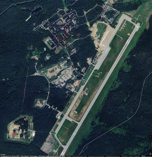
L55.4339z42.2868 (red mark) and runway of the Savasleika Airbase (Авиабаза Саваслейка) at the Google map
References
https://www.google.co.jp/maps/place/55°26'02.2%22N+42°17'12.1%22E/@55.4432969,42.2836859,2758m/data=!3m1!1e3!4m4!3m3!8m2!3d55.43393!4d42.28669?hl=ru&entry=ttu 55°26'02.2"N 42°17'12.1"E 55.433930, 42.286690
Кулебакский р-н, Нижегородская обл., Россия C7MP+HMG Саваслейка, Нижегородская обл., Россия
Keywords
«Annexation of Crimea», «Budapest memorandum», «L55.4339z42.2868», «Savasleika Airbase», «Авиабаза Саваслейка», «Спецоперация»,
File history
Click on a date/time to view the file as it appeared at that time.
| Date/Time | Thumbnail | Dimensions | User | Comment | |
|---|---|---|---|---|---|
| current | 17:07, 16 August 2024 | | 972 × 1,008 (259 KB) | T (talk | contribs) | == Summary == {{oq|L55.4339z42.2868savasleikaMap.jpg|}} L55.4339z42.2868 (red mark) and runway of the Savasleika Airbase (Авиабаза Саваслейка) at the Google map ==References== {{ref}} https://www.google.co.jp/maps/place... |
- You cannot overwrite this file.
File usage
The following page links to this file: