File:MargoBridge.jpg

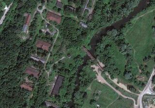
Google aerial map of the wreck of the Bridge of the Queen Margo ("Мост Королевы Марго") destroyed after Margo and her Friend passed by.
The wreck of the bridge is at the center.
At the right, bottom: the rest of the railroad, it was also destroyed after the problem with the bridge.
At the top and at the left: the secret military factory and the research laboratory. After the accident, the most of factory was translated approximately one screen down (id est, South), close to another railroad which is also seen from the satellite (at least for year 2010).
At the reuse, please, attribute the sources:
http://maps.google.com/?ie=UTF8&ll=55.8070,37.0868&z=18 Google map
http://samlib.ru/k/kuznecow_d_j/margo.shtml D.Kouznetsov. Bridge of the Queen Margo ("Мост Королевы Марго", in Russian)
File history
Click on a date/time to view the file as it appeared at that time.
| Date/Time | Thumbnail | Dimensions | User | Comment | |
|---|---|---|---|---|---|
| current | 17:50, 20 June 2013 | | 1,184 × 822 (69 KB) | Maintenance script (talk | contribs) | Importing image file |
- You cannot overwrite this file.
File usage
There are no pages that link to this file.