File:TambovskiPorohovoiZavodMap8.jpg
Summary
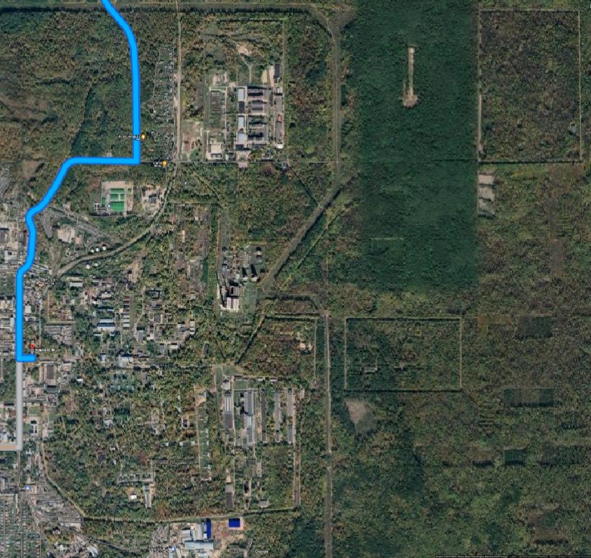
Tambovski Porohovoi Zavod (Тамбовский пороховой завод) at the Google Map[1]
The main location (Southern of the two) [2] is shown:
Адрес (main production facility): 393190, Тамбовская область, г. Котовск, пр. Труда, 23
Coordinates:
52.5892, 41.5074 Вч 6891
52.5934, 41.5123 West (main) gate
52.6028, 41.5258 North railroad gate
52.5932, 41.5205 Arsenal
52.5992, 41.5309 Fuel storage
52.5999, 41.5148 Fuel storage
52.5969, 41.5129 Administration
52.5918, 41.5091 auto transport department
52.5924, 41.5109 Fire department
52.5930, 41.5166 Electric power supply
52.5973, 41.5282 Electric power supply
52.5815, 41.5057 KGB (РПЦ) office
Warning: The recognition of the objects listed above is performed on the base of visual observation of the maps. The identification may have mistakes and needs an independent confirmation.
References
- ↑ https://www.google.com/maps/dir/Internatsional'naya+Ulitsa,+13,+Tambov,+Tambovskaya+oblast',+Russia,+392000/Prospekt+Truda,+23,+Kotovsk,+Tambovskaya+oblast',+Russia,+393190/@52.6601317,41.065629,11z/data=!4m14!4m13!1m5!1m1!1s0x4139142c33a01ae3:0x7ec17093abd14aca!2m2!1d41.4543819!2d52.7219077!1m5!1m1!1s0x413940a4de93ae79:0x13cf2c95d2275e30!2m2!1d41.507314!2d52.5935228!3e0?entry=ttu Internatsional'naya Ulitsa, 13, Tambov, Tambovskaya oblast', Russia, 392000 Prospekt Truda, 23, Kotovsk, Tambovskaya oblast', Russia, 393190
- ↑ https://www.google.com/maps/search/Тамбовский+пороховой+завод/@52.6579751,41.318404,20655m/data=!3m1!1e3?entry=ttu Тамбовский пороховой завод Kotovsk, pr.Truda, 23 Kotovsk, Internacionalnaya ulitsa, 13
File history
Click on a date/time to view the file as it appeared at that time.
| Date/Time | Thumbnail | Dimensions | User | Comment | |
|---|---|---|---|---|---|
| current | 08:38, 14 November 2023 | | 846 × 799 (343 KB) | T (talk | contribs) | {{oP}} Tambovski Porohovoi Zavod (Тамбовский пороховой завод) at the Google Map<ref name="g2"><small> https://www.google.com/maps/dir/Internatsional'naya+Ulitsa,+13,+Tambov,+Tambovskaya+oblast',+Russia,+392000/Prospekt+... |
- You cannot overwrite this file.
File usage
The following page links to this file: