Search results
Create the page "Google map" on this wiki! See also the search results found.
- ...ical representation of such a function. Such a representation is called '''map'''. ...n of a point on the surface of the Earth to the corresponding point of the map. In both cases, it is assumed that "everybody knows" the specific kind of m14 KB (2,275 words) - 18:25, 30 July 2019
- [[File:TsarBombMap01.jpg|500px|thumb|Google map at 73.80722, 54.98167]] Tsar Bomb Google Earth location. oopiuhgkg Uploaded on Nov 7, 2011</ref>13 KB (169 words) - 07:36, 1 December 2018
- | format= – <sup>[http://scholar.google.co.uk/scholar?hl=en&lr=&q=author%3A+intitle%3AScaling+laws+of+a+thin+disk+l |format= – <sup>[http://scholar.google.co.uk/scholar?hl=en&lr=&q=author%3A+intitle%3ABroadband+laser+materials+and12 KB (1,757 words) - 07:01, 1 December 2018
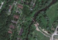
File:MargoBridge.jpg http://maps.google.com/?ie=UTF8&ll=55.8070,37.0868&z=18 Google map(1,184 × 822 (69 KB)) - 20:42, 10 September 2013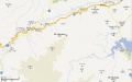
File:Yakiyama01map.jpg Map of Yakiyama mount (35.539 N,139.164 E) and vicinity by Google, http://maps.google.com/?ll=35.591017,139.196091&spn=0.050952,0.070381&t=m&z=13&vpsrc=6(1,895 × 1,190 (234 KB)) - 09:40, 21 June 2013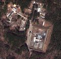
File:Reshety.jpg Snapshot from the Google [[map]], https://maps.google.com/maps?&ll=56.855,60.241 The honest use is assumed, attribute the GOOGLE at the reproduction.(1,909 × 1,839 (1.29 MB)) - 11:02, 27 August 2013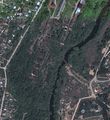
File:MargoBridge3.jpg http://maps.google.com/?ie=UTF8&ll=55.8070,37.0868&z=18 Google map, 2013 [[Category:Google maps]](1,874 × 2,039 (1.66 MB)) - 21:18, 10 September 2013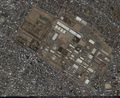
File:35.58194 139.37917.jpg [[Sagami military base]], Google map at [[Category:Map]](1,346 × 1,102 (607 KB)) - 08:27, 1 December 2018
File:42.2053 43.9816.jpg Google map at 42.2053_43.9816 [[Category:Map]](1,644 × 945 (605 KB)) - 08:27, 1 December 2018
File:42.22766 43.9746.jpg Google map at 42.22766_43.9746 [[Category:Map]](1,405 × 857 (398 KB)) - 08:27, 1 December 2018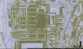
File:42.2367 43.9587.jpg Google map at 42.2367,43.9587 , North part of [[vh66431]] ([[Вч 66431]] ) [[Category:Map]](1,625 × 956 (407 KB)) - 08:27, 1 December 2018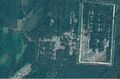
File:53.4663 33.9445.jpg Google map at [[53.4663,33.9445]](1,659 × 1,094 (923 KB)) - 08:28, 1 December 2018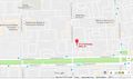
File:55.80426 37.81266.jpg Google map at 55.80426_37.81266 https://www.google.com/maps/place/55°48'15.3%22N+37°48'45.6%22E/@55.804266,37.8104743,17z/da(1,482 × 873 (179 KB)) - 08:28, 1 December 2018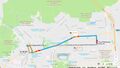
File:AbbazovMap.jpg Google driving direction between points https://www.google.com/maps/dir/55.802245,37.707104/'55.80426,37.81266'/@55.8145838,37.7479516(1,518 × 866 (252 KB)) - 08:28, 1 December 2018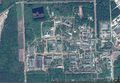
File:AvangardSarovMap.jpg Google map of the central part of [[Avangard Sarov]] ([[Авангард Саров]])(1,599 × 1,103 (906 KB)) - 08:30, 1 December 2018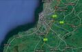
File:AyrAllowayMap.jpg Google map of vicinity of bridge across river Doon (B7024 Ayr KA7, UK, coordinates: 55 [[Category:Map]](1,285 × 815 (199 KB)) - 08:30, 1 December 2018
File:BarabashMap0.jpg Google map of vicinity of town Barabash, 43.19234, 131.50865 [[Category:Map]](604 × 425 (86 KB)) - 08:30, 1 December 2018
File:BatskihMap.jpg Google map at 55.73932, 37.76328 [[Category:Map]](1,496 × 1,090 (739 KB)) - 08:30, 1 December 2018
File:BatskihZoomOut.jpg Google map at 55.73932, 37.76328 and [[Category:Map]](1,374 × 1,083 (803 KB)) - 08:30, 1 December 2018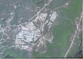
File:Borzoi.jpg Google map of посёлок Борзой(1,555 × 1,099 (638 KB)) - 08:31, 1 December 2018


