Search results
Create the page "Google map" on this wiki! See also the search results found.
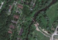
File:MargoBridge.jpg http://maps.google.com/?ie=UTF8&ll=55.8070,37.0868&z=18 Google map(1,184 × 822 (69 KB)) - 20:42, 10 September 2013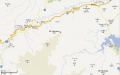
File:Yakiyama01map.jpg Map of Yakiyama mount (35.539 N,139.164 E) and vicinity by Google, http://maps.google.com/?ll=35.591017,139.196091&spn=0.050952,0.070381&t=m&z=13&vpsrc=6(1,895 × 1,190 (234 KB)) - 09:40, 21 June 2013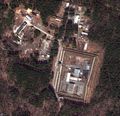
File:Reshety.jpg Snapshot from the Google [[map]], https://maps.google.com/maps?&ll=56.855,60.241 The honest use is assumed, attribute the GOOGLE at the reproduction.(1,909 × 1,839 (1.29 MB)) - 11:02, 27 August 2013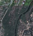
File:MargoBridge3.jpg http://maps.google.com/?ie=UTF8&ll=55.8070,37.0868&z=18 Google map, 2013 [[Category:Google maps]](1,874 × 2,039 (1.66 MB)) - 21:18, 10 September 2013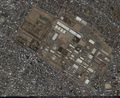
File:35.58194 139.37917.jpg [[Sagami military base]], Google map at [[Category:Map]](1,346 × 1,102 (607 KB)) - 08:27, 1 December 2018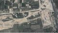
File:42.2053 43.9816.jpg Google map at 42.2053_43.9816 [[Category:Map]](1,644 × 945 (605 KB)) - 08:27, 1 December 2018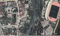
File:42.22766 43.9746.jpg Google map at 42.22766_43.9746 [[Category:Map]](1,405 × 857 (398 KB)) - 08:27, 1 December 2018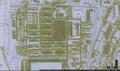
File:42.2367 43.9587.jpg Google map at 42.2367,43.9587 , North part of [[vh66431]] ([[Вч 66431]] ) [[Category:Map]](1,625 × 956 (407 KB)) - 08:27, 1 December 2018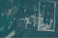
File:53.4663 33.9445.jpg Google map at [[53.4663,33.9445]](1,659 × 1,094 (923 KB)) - 08:28, 1 December 2018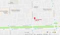
File:55.80426 37.81266.jpg Google map at 55.80426_37.81266 https://www.google.com/maps/place/55°48'15.3%22N+37°48'45.6%22E/@55.804266,37.8104743,17z/da(1,482 × 873 (179 KB)) - 08:28, 1 December 2018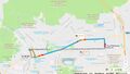
File:AbbazovMap.jpg Google driving direction between points https://www.google.com/maps/dir/55.802245,37.707104/'55.80426,37.81266'/@55.8145838,37.7479516(1,518 × 866 (252 KB)) - 08:28, 1 December 2018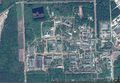
File:AvangardSarovMap.jpg Google map of the central part of [[Avangard Sarov]] ([[Авангард Саров]])(1,599 × 1,103 (906 KB)) - 08:30, 1 December 2018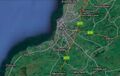
File:AyrAllowayMap.jpg Google map of vicinity of bridge across river Doon (B7024 Ayr KA7, UK, coordinates: 55 [[Category:Map]](1,285 × 815 (199 KB)) - 08:30, 1 December 2018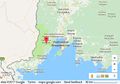
File:BarabashMap0.jpg Google map of vicinity of town Barabash, 43.19234, 131.50865 [[Category:Map]](604 × 425 (86 KB)) - 08:30, 1 December 2018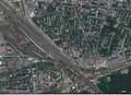
File:BatskihMap.jpg Google map at 55.73932, 37.76328 [[Category:Map]](1,496 × 1,090 (739 KB)) - 08:30, 1 December 2018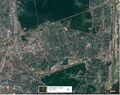
File:BatskihZoomOut.jpg Google map at 55.73932, 37.76328 and [[Category:Map]](1,374 × 1,083 (803 KB)) - 08:30, 1 December 2018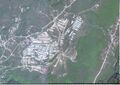
File:Borzoi.jpg Google map of посёлок Борзой(1,555 × 1,099 (638 KB)) - 08:31, 1 December 2018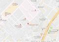
File:BotMap2.jpg [[Боткинская больница]], google map at 55.7796, 37.55332 https://www.google.com/maps/place/2-y+Botkinskiy+pr-d,+5к17,+Moskva,+Russia,+125284/@55.78054(1,166 × 833 (228 KB)) - 08:31, 1 December 2018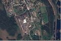
File:ColonyKeygubskaya.jpg Google map at Segezhsky District, Republic of Karelia, Russia, https://www.google.com/maps/dir///@63.7751652,34.2950426,891m/data=!3m1!1e3(1,428 × 953 (525 KB)) - 08:32, 1 December 2018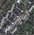
File:DerbyshkiMap.jpg Google map of police office [[Derbyshki]], [[Category:Map]](834 × 842 (267 KB)) - 08:34, 1 December 2018


