Search results
Create the page "Google map" on this wiki! See also the search results found.
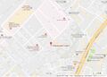
File:BotMap2.jpg [[Боткинская больница]], google map at 55.7796, 37.55332 https://www.google.com/maps/place/2-y+Botkinskiy+pr-d,+5к17,+Moskva,+Russia,+125284/@55.78054(1,166 × 833 (228 KB)) - 08:31, 1 December 2018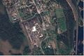
File:ColonyKeygubskaya.jpg Google map at Segezhsky District, Republic of Karelia, Russia, https://www.google.com/maps/dir///@63.7751652,34.2950426,891m/data=!3m1!1e3(1,428 × 953 (525 KB)) - 08:32, 1 December 2018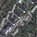
File:DerbyshkiMap.jpg Google map of police office [[Derbyshki]], [[Category:Map]](834 × 842 (267 KB)) - 08:34, 1 December 2018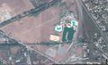
File:GudermesMap.jpg [[Category:Google]] [[Category:Map]](1,829 × 1,120 (587 KB)) - 08:37, 1 December 2018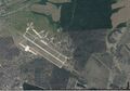
File:HalinoMap.jpg Google map of Halino, [[vh23243]] ([[Вч 23243]]),(1,563 × 1,093 (543 KB)) - 08:37, 1 December 2018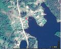
File:HotelSiamozeroMap.jpg Google map of [[Hotel Siamozero]] https://www.google.com/maps/place/Hotel+Syamozero/@61.9072717,33.016101,522m/data=!3m1!1e3!4m5(1,314 × 1,063 (487 KB)) - 08:38, 1 December 2018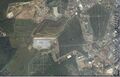
File:HovanCemeteryMap.jpg Google map at 55.60855, 37.44128 [[Category:Map]](1,704 × 1,092 (668 KB)) - 08:38, 1 December 2018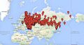
File:Karta-rf.jpg ...интерактивный вариант этой карты https://www.google.com/maps/d/viewer?mid=1a1oXUvWbZY3X5ohseoumaoUILBg и его описани https://www.google.com/maps/d/viewer?mid=1a1oXUvWbZY3X5ohseoumaoUILBg(783 × 421 (134 KB)) - 13:12, 2 September 2023
File:Kerch2014.04.10.jpg ...rom Berdiansk and from Mariupol), with warplanes there, satellite view by Google. https://www.google.com/maps/place/46°03'26.0%22N+38°14'00.0%22E/@46.0572222,38.2333333,2808m(3,148 × 657 (725 KB)) - 08:39, 1 December 2018
File:Kirova24LogunovMap.jpg Google map at 51.52094, 38.03664 [[Category:Map]](1,680 × 1,075 (703 KB)) - 08:40, 1 December 2018
File:KommunarkaMap.jpg Google map of [[kommunarka]] at 55.5792, 37.4558, Soviet [[concentration camp]], used [[Category:Map]](578 × 548 (138 KB)) - 08:40, 1 December 2018
File:KomsomolskNaAmureAir.jpg Google map of the airport of Komsomolsk na Amure [[Category:Map]](1,499 × 1,086 (628 KB)) - 08:40, 1 December 2018
File:Kondratev F.V.jpg ...ed on OpenStreetMap. View this and other nearby images on: OpenStreetMap - Google Earth(2,448 × 3,264 (1.65 MB)) - 08:40, 1 December 2018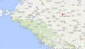
File:Kulakova13.jpg Google map at(1,404 × 815 (362 KB)) - 08:41, 1 December 2018
File:KuschevkaMap.jpg [[Kuschevka]], map of [[Кущевка]] (Станица Кущевская) [[Category:Map]](1,263 × 1,068 (370 KB)) - 08:41, 1 December 2018
File:Laes2map2.jpg [[ЛАЭС2]], google [[map]] [[Category:Map]](1,641 × 1,103 (736 KB)) - 08:41, 1 December 2018
File:Laes2map3.jpg [[ЛАЭС2]], google [[map]] [[Category:Map]](1,651 × 1,101 (637 KB)) - 08:41, 1 December 2018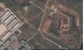
File:Map42.828144,47.09984.jpg Google map at [[Category:Map]](1,559 × 936 (392 KB)) - 08:42, 1 December 2018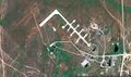
File:Map51.04698,59.85672vh.jpg Google map of the airbase of [[vh93766]] at 51.04698,59.85672 [[Category:Map]](1,846 × 1,096 (770 KB)) - 08:42, 1 December 2018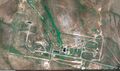
File:Map51.09307 59.84402vh.jpg Google map of the rocket base of [[vh93766]] at 51.09307,59.84402(1,847 × 1,098 (837 KB)) - 08:42, 1 December 2018


