File:CrymMap.jpg

Summary
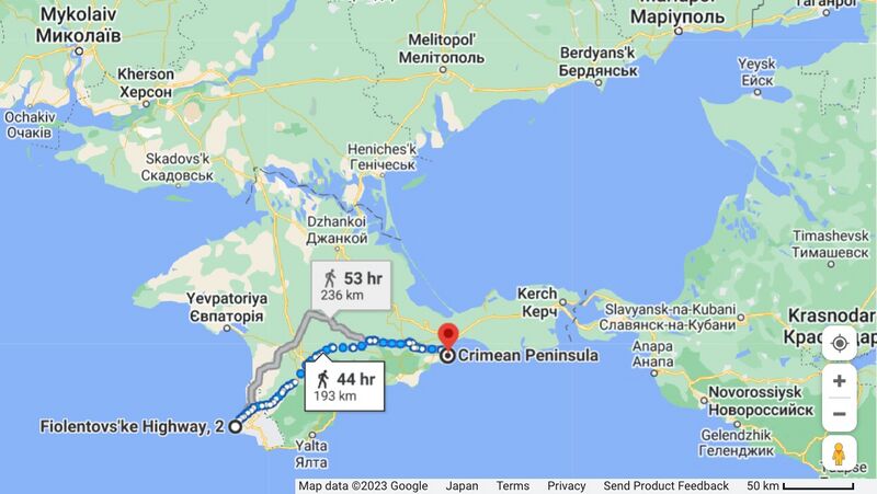
Some objects believed to belong to Vh85683 (Вч 85683) at the map of Crimea by Google[1]
Евпатория, Саки и другие места дислокации российких военных объектов орков в оккупированном Крыму на гуглевской карте [1]
Судя по карте, по крайней мере с 2023 года, российские военные базы в окрестностях Евпатории
входят в область применимисти ракет со стомильным радиусом действия.
Можно ожидать появления сообщений о бавовнах на этих базах.
References
Keywords
«Annexation of Crimea», «Bavovna», «Budapest memorandum», «Putin World War», «Russian invasion into Ukraine», «Stop Putin», «Vh85683», «[[]]»,
«А нас то за что», «Аннексия Крыма», «Бавовна», «Вч 85683», «Евпатория», «Пусть земля горит под ногами оккупантов», «Путинская мировая война», «Российское вторжение в Украину», «Спецоперация», «Террор»,
File history
Click on a date/time to view the file as it appeared at that time.
| Date/Time | Thumbnail | Dimensions | User | Comment | |
|---|---|---|---|---|---|
| current | 18:17, 15 September 2023 | | 1,265 × 713 (209 KB) | T (talk | contribs) | <div style="margin:-18px -14px 0px -200px; background-color:#fff"> <div style="margin:0px 0px 0px 30px; line-height:1.2em"><br> Some objects believed to belong to Vh85683 (Вч 85683) at the map of Crimea by Google<ref name="cm"><small> https... |
- You cannot overwrite this file.
File usage
The following page links to this file: