Search results
Create the page "Aerial" on this wiki! See also the search results found.
- <i> The Energy Department used its Aerial Measuring System (AMS) between March 17 and 19, 2011, and compiled a detail42 KB (5,776 words) - 12:14, 20 November 2021
- <i> The Energy Department used its Aerial Measuring System (AMS) between March 17 and 19, 2011, and compiled a detail45 KB (6,219 words) - 15:14, 21 August 2019
- '''Answer'''. The aerial map of contmination by the [[U.S. Department of Energy]] ...misoma: the contamination of sources of water (that is not detected at the aerial measurements) may be also important parameter.26 KB (3,915 words) - 18:25, 30 July 2019
- [[File:KGB01c.jpg|300px|right|thumb|Aerial view of Lubianka, the main office of KGB]]12 KB (1,506 words) - 18:58, 3 December 2020
- //Julia Ioffe. Two cops just told me there are more than 70,000 according to aerial count.// //Julia Ioffe. Two cops just told me there are more than 70,000 according to aerial count.//49 KB (713 words) - 14:56, 20 June 2013
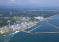
File:FukushimaPowerPlant-1.jpg Aerial photo of the [[Fukushima nuclear plant]] [[Category:Aerial views]](582 × 416 (202 KB)) - 17:50, 20 June 2013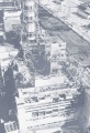
File:4block-698x1024.jpg [[Chernobyl disaster]], Aerial view of the ruins of the building of the 4th block, when the reactor and it(698 × 1,024 (199 KB)) - 09:41, 21 June 2013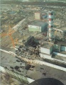
File:Chernobyl Disaster.jpg This is aerial photo or the Chernobyl nuclear station after the explosion in 1986 April 26(500 × 646 (95 KB)) - 09:38, 21 June 2013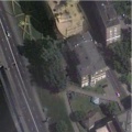
File:Ham100.jpg Aerial view of the Khamovnichesky court ([[Хамовнический суд]], М [[Category:Aerial view]](554 × 554 (48 KB)) - 09:42, 21 June 2013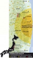
File:Image-202028-galleryV9-ehmb.jpg The same conclusions can be done on the aerial measurements map(343 × 600 (88 KB)) - 09:38, 21 June 2013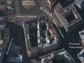
File:Kgbmap0.jpg Aerial view of Lubyaka, main office of the [[KGB]], ideologic police of the USSR a(1,279 × 959 (85 KB)) - 08:39, 1 December 2018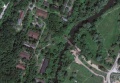
File:MargoBridge.jpg Google aerial map of the wreck of the Bridge of the Queen Margo ("Мост Королев(1,184 × 822 (69 KB)) - 20:42, 10 September 2013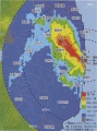
File:Newton2011 7 27b.jpg ...represents the Pacific Ocean, that does not show its contamination at the aerial view.(1,025 × 1,377 (81 KB)) - 09:38, 21 June 2013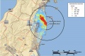
File:Si-radiation-thumb-200xauto-6005b.jpg Cumulative Aerial map of contamination after the [[Fukushima disaster]] for(1,520 × 1,002 (71 KB)) - 09:38, 21 June 2013- <ref>http://www.thetimes.co.uk/article/russia-unleashes-lethal-aerial-arsenal-on-aleppo-q73c8dll3 Hannah Lucinda Smith. Russia unleashes lethal aerial arsenal on Aleppo.148 KB (18,467 words) - 18:50, 13 January 2022
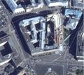
File:Lubianka2013aug.jpg Aerial view of Lubyaka, main office of the [[KGB]], ideologic police of the [[USSR(2,076 × 1,868 (828 KB)) - 08:42, 1 December 2018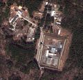
File:Reshety.jpg aerial view.(1,909 × 1,839 (1.29 MB)) - 11:02, 27 August 2013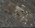
File:35.58194 139.37917.jpg An aerial view of a warehouse which caught fire after an explosion at the US Army Sag(1,346 × 1,102 (607 KB)) - 08:27, 1 December 2018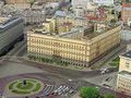
File:LubiankaS.jpg Aerial view of Lubyanka at the approach from South.(260 × 194 (16 KB)) - 08:42, 1 December 2018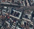
File:Motf02.jpg [[MO RF]], aerial view at the approach from East.(1,078 × 939 (338 KB)) - 08:43, 1 December 2018


