Search results
Create the page "Satellite" on this wiki! See also the search results found.
- ...t Yubileiny satellite which was launched into orbit almost a year ago. The satellite can now move from one orbit to another with the help of the engine, which d26 KB (3,318 words) - 18:25, 19 June 2020
- ...his first broadcast interview with western media, said verified photos and satellite images of dead civilians in the streets of Ukrainian cities were a "bold fa44 KB (962 words) - 15:55, 16 October 2022
- Is only a satellite. <br>45 KB (958 words) - 07:17, 1 December 2018
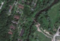
File:MargoBridge.jpg ...own (id est, South), close to another railroad which is also seen from the satellite (at least for year 2010).(1,184 × 822 (69 KB)) - 20:42, 10 September 2013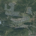
File:Sagra.jpg Satellite view of the village [[Sagra]], Sverdlovskaya oblast, Russia, famous for the [[Category:Satellite view]](1,647 × 1,657 (243 KB)) - 09:39, 21 June 2013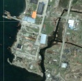
File:Shikotango.jpg Satellite view of the central part of island Shikotan with the structures that look l [[Category:Satellite view]](762 × 757 (175 KB)) - 09:38, 21 June 2013- ...nce source said: “Up till now RAF Tornados have been equipped with 500lb satellite-guided bombs — there has been no or little air-to-air threat. But in the ...tremely inaccurate and fragile, in particular, due to loss of many Glonass satellite at the frequent crashes of the Russian rockets at the launch.148 KB (18,467 words) - 18:50, 13 January 2022
File:Lubianka2013aug.jpg Source: Google satellite service(2,076 × 1,868 (828 KB)) - 08:42, 1 December 2018- the satellite figure shows the structures which could be the water-withdrawal and water-r ...y rectangular structure means the nuclear-waste deposit pool; perhaps, the satellite view is not sufficient for the identification even by a specialist. But I c11 KB (1,349 words) - 18:25, 30 July 2019

File:CosmicForecast01.jpg SATELLITE IN SPACE ...from sunlight unfiltered by atmosphere, look out on a 1929 conception of a satellite.(2,420 × 3,220 (3.19 MB)) - 16:26, 5 January 2024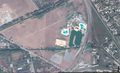
File:GudermesMap.jpg Satellite view at Gudermessky District, Chechnya, Russia 43.35456, 46.09120.(1,829 × 1,120 (587 KB)) - 08:37, 1 December 2018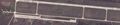
File:Kerch2014.04.10.jpg ...Kerch peninsula, from Berdiansk and from Mariupol), with warplanes there, satellite view by Google.(3,148 × 657 (725 KB)) - 08:39, 1 December 2018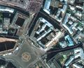
File:Lubianka2014.jpg Satellite view of [[Lubianka]] (Main office of the Russian [[KGB]]), satellite view by [[Category:Satellite]](1,260 × 1,032 (469 KB)) - 08:42, 1 December 2018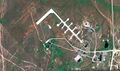
File:Map51.04698,59.85672vh.jpg ...erceptor squadrons and an ICBM base (which has been adapted for commercial satellite launches).(1,846 × 1,096 (770 KB)) - 08:42, 1 December 2018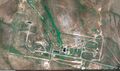
File:Map51.09307 59.84402vh.jpg ...erceptor squadrons and an ICBM base (which has been adapted for commercial satellite launches).(1,847 × 1,098 (837 KB)) - 08:42, 1 December 2018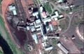
File:ShahtaSevernayaGo.jpg [[Shahta Severnaya]], Satellite view by Google, https://www.google.com/maps/place/67%C2%B035'14.1%22N+64%C2(1,675 × 1,091 (389 KB)) - 08:51, 1 December 2018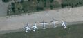
File:Yeysk2014.04.10.jpg Warcrafts at Yeysk, seen from satellite, state for 2014.04.10.(1,786 × 823 (353 KB)) - 08:57, 1 December 2018- :: The hole has a satellite4 KB (561 words) - 20:07, 28 March 2020
- [[File:AvangardSarovMap.jpg|180px|thumb| [[Avangard Sarov]] satellite view]]11 KB (1,522 words) - 07:00, 1 December 2018
- ...age, shown 2014.11.14 by [[Russia1]] pretending to be a photo taken from a satellite]] ...the interpretation of operators of [[Russia1]], that image is taken from a satellite. The simple estimate indicates, that the4 KB (293 words) - 07:04, 1 December 2018


