Search results
Create the page "Trail" on this wiki! See also the search results found.

File:MzAxMTkwNw.jpeg ...ect to that work. In that work in fact, the network was just recognizing a trail and deriving, from the output, a discrete action to take (center, left, rig ...he case for example when placing the drone within a forest without a clear trail to be followed.(1,240 × 827 (505 KB)) - 19:53, 4 January 2020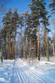
File:SnowTreesInga.jpg Snow, trees and ski trail by [[Татьяна Мишустина]], 2020(511 × 768 (116 KB)) - 16:58, 20 January 2020- for peaceful purposes, and that it should have blazed a trail287 KB (44,593 words) - 02:17, 10 July 2020
- Soon, Ruvim occasionally hangs his biper at the bush near the trail. Since that, Pupkin already cannot communicate him. Ruvim reaches the place ...d Ruvim gets dressed. Pupkin knows that place, he brings Ruvim to the good trail and forces Ruvim to run heading the campus.14 KB (2,066 words) - 14:47, 4 December 2020
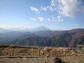
File:04375fuji.jpg View at Fuji from trail to Sannoto(2,048 × 1,536 (1.36 MB)) - 12:45, 22 November 2020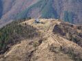
File:04379firstRefugeSma.jpg First refuge Sannoto on the trail from road 70 to Tounnodake(2,048 × 1,536 (1.03 MB)) - 12:49, 22 November 2020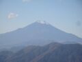
File:04376fuji.jpg View at Fuji san from the trail to Sannoto.(2,048 × 1,536 (975 KB)) - 18:05, 22 November 2020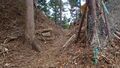
File:04476throughFence.jpg Saddle point of the trail along river Hayato.(1,920 × 1,080 (899 KB)) - 16:45, 1 December 2020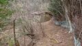
File:04477refuge.jpg Refuge at the trail along river Hayato.(1,920 × 1,080 (855 KB)) - 16:48, 1 December 2020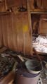
File:04478refuge.jpg Refuge at trail along river Hayato, inside.(1,080 × 1,920 (838 KB)) - 16:50, 1 December 2020
File:04479walkByLog.jpg Log as bridge at the trail along Hayato river.(1,920 × 1,080 (856 KB)) - 16:54, 1 December 2020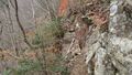
File:04489brokenBridge.jpg Broken bridge at the trail.(1,920 × 1,080 (859 KB)) - 17:14, 1 December 2020
File:04772TrailRidge.jpg [[2021.05.15.Aone]] hike: Trail at the ridge. [[Category:Trail]](2,408 × 1,806 (1.77 MB)) - 23:31, 16 May 2021
File:04773shoka.jpg [[2021.05.15.Aone]] hike: trail(2,408 × 1,806 (1.78 MB)) - 23:32, 16 May 2021
File:04797shokoRidge.jpg [[2021.05.23.Hike]]: Trail at ridge(2,189 × 1,642 (1.47 MB)) - 22:20, 23 May 2021- [[⾄]] ([[X2F84]]) may denote a terminal point of a trail;3 KB (382 words) - 07:48, 25 July 2021
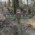
File:Himetugi2.jpeg Board at the trail from mount [[Himetsugi]] to mount [[Hirugatake]](225 × 225 (14 KB)) - 05:37, 6 August 2021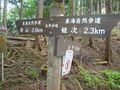
File:04974himetsugu26.jpg Trail from [[Yakiyama]] to [[Himetugi]].(2,048 × 1,536 (1.34 MB)) - 10:52, 6 August 2021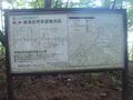
File:04977map.jpg [[2021.07.31.Hike]], first day; trail from [[Yakiyama]] to [[Himetugu]].(2,048 × 1,536 (1.22 MB)) - 10:59, 6 August 2021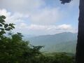
File:04978view.jpg View North from the trail [[Yakiyama]] - [[Himetugi]](2,048 × 1,536 (1.16 MB)) - 11:03, 6 August 2021


