File:BorderlinesBalticsFragment.jpg
Summary
Fragment from image 100px Borderlines_BalticsSmall.jpg
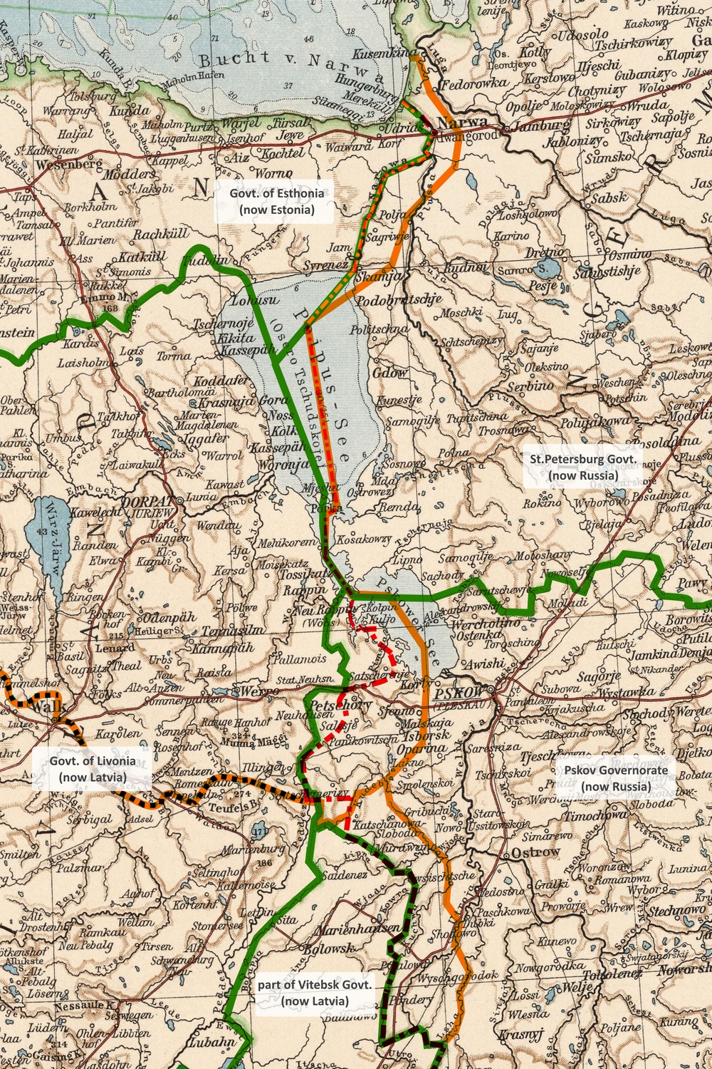
Territories of Estonia and Latvia seized by the Soviet aggressors at the World War II.
Black dotterd line show border between Estonia and Latvia.
Orange line represents borders before World War II,
according to agreement TartuER:
1920.02.02 Agreement between Estonia and Russia about the border
Rahuleping Eesti ja Venemaa vahel. (Eesti)
Мирный договор между Россией и Эстонией. (Russian)
Green line represent Governorate borders of 1906 and also boundaries of territory that has been seized by the Red Army at World War II and to year 2021 is still controlled by agents of the Russian KGB.
Explanation at bottom, out of field
Explanation at bottom of the original, that happen to be out of field of this image:
Source and pre-1920 borderlines. Westruszland, Nordlicher Teil, Richard Andee & Albert Scobel, Andree Handatlas, Ausgabe #5, Verlag Von Verhaken & Classing 1906
1920 - borderline info: Prussia orientale, Stati Baltici., Touring club italiano, Ufficio cartografico del T.C.I., Milano, 1929
1944 - borderline info: Byelorussian SSR, Lithuanian SSR, Latvian SSR and Kaliningrad region of RSFSR, U.S.S., 1967
Topograficheskie karty Generalnogo shtaba, list O-35, Moscow, 1944-1989
Description
Up to year 2021, regions between orange and green lines are still occupied by Russian troops and controlled by agents of KGB.
The original is loaded from MediaWiki [1].
Original filename: https://upload.wikimedia.org/wikipedia/commons/0/0a/Borderlines_Baltics.jpg
Original description:
https://commons.wikimedia.org/wiki/File:Borderlines_Baltics.jpg
English: Evolution of borders between Russia, Latvia and Estonia in 20-th Century
Русский: Формирование границ России, Латвии и Эстонии в 20-м веке
Date 1 January 2019
Source Own work
Author Brandmajor
Reference
- ↑ https://commons.wikimedia.org/wiki/File:Borderlines_Baltics.jpg English: Evolution of borders between Russia, Latvia and Estonia in 20-th Century Русский: Формирование границ России, Латвии и Эстонии в 20-м веке Date 1 January 2019 Source Own work Author Brandmajor
File history
Click on a date/time to view the file as it appeared at that time.
| Date/Time | Thumbnail | Dimensions | User | Comment | |
|---|---|---|---|---|---|
| current | 11:06, 7 November 2021 | | 1,000 × 1,500 (1.57 MB) | T (talk | contribs) | Fragment from image 100px Borderlines_BalticsSmall.jpg Territories of Estonia and Latvia seized by the Soviet aggressors at the World War II. Black dotterd line show border between Estonia and Latvia.... |
- You cannot overwrite this file.
File usage
There are no pages that link to this file.