Difference between revisions of "File:WuhanMap861776 600.png"
m (T moved page File:Wuhan861776 600.png to File:WuhanMap861776 600.png) |
|
| (One intermediate revision by the same user not shown) | |
(No difference)
| |
Latest revision as of 22:23, 7 May 2020
Map [1] of Wuhan, used in analysis of sources of pandemic of Coronavirus in 2019.
Orignal filename: https://ic.pics.livejournal.com/aillarionov/14234704/861776/861776_600.png
References
- ↑ https://img-prod.tgcom24.mediaset.it/images/2020/02/16/114720192-5eb8307f-017c-4075-a697-348628da0204.pdf Botao Xiao, Lei Xiao. The possible origins of 2019-nCoV coronavirus. 2020.02.06. The 2019-nCoV coronavirus has caused an epidemic of 28,060 laboratory-confirmed infections in human including 564 deaths in China by February 6, 2020. Two descriptions of the virus published on Nature this week indicated that the genome sequences from patients were 96% or 89% identical to the Bat CoV ZC45 coronavirus originally found in Rhinolophus affinis 1,2. It was critical to study where the pathogen came from and how it passed onto human.
File history
Click on a date/time to view the file as it appeared at that time.
| Date/Time | Thumbnail | Dimensions | User | Comment | |
|---|---|---|---|---|---|
| current | 22:19, 7 May 2020 | 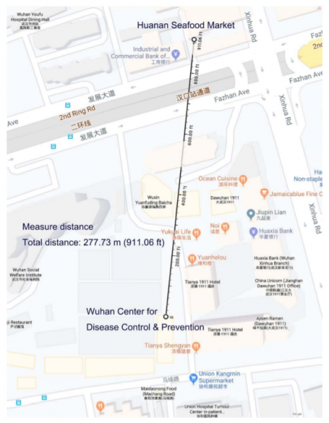 | 466 × 600 (309 KB) | T (talk | contribs) |
- You cannot overwrite this file.
File usage
The following 2 pages link to this file:
- Coronavirus as accident
- File:Wuhan861776 600.png (file redirect)