Search results
Create the page "Google maps" on this wiki! See also the search results found.
- ...lactic meridian]] at the sky sphere. Similarly, the geophysicists use some maps without to know what kind of function (it is called "projection") relates t For the plotting of the maps of a function of two real variables, the function [[contour plot]] can be u14 KB (2,275 words) - 18:25, 30 July 2019
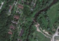
File:MargoBridge.jpg http://maps.google.com/?ie=UTF8&ll=55.8070,37.0868&z=18 Google map(1,184 × 822 (69 KB)) - 20:42, 10 September 2013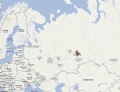
File:SagraGmap.jpg http://maps.google.com/maps?q=57.0319,60.3&ll=59.977005,51.240234&spn=29.51006,85.693359&z=4 Copyright of this image belongs to Google. The honest use is assumed.(1,200 × 915 (55 KB)) - 09:39, 21 June 2013
File:MargoBridge3.jpg http://maps.google.com/?ie=UTF8&ll=55.8070,37.0868&z=18 Google map, 2013 [[Category:Maps]](1,874 × 2,039 (1.66 MB)) - 21:18, 10 September 2013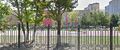
File:BalashikhaOktiabrskaya7.jpeg by Google. ...be location of the [[Железнодорожный УИК 580]] by Google maps,(402 × 168 (35 KB)) - 08:30, 1 December 2018
File:Dubinski745504 600.jpg (241 × 300 (12 KB)) - 08:34, 1 December 2018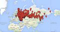
File:Karta-rf.jpg ...активный вариант этой карты https://www.google.com/maps/d/viewer?mid=1a1oXUvWbZY3X5ohseoumaoUILBg и его описание https://www.google.com/maps/d/viewer?mid=1a1oXUvWbZY3X5ohseoumaoUILBg(783 × 421 (134 KB)) - 13:12, 2 September 2023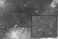
File:MigKilometer558528.jpg ...Он сфабрикован на основании снимков Google Maps от 28/8/2012, координаты: 47°57’18.03’’N, 37°50’10.26(7,406 × 5,000 (1.56 MB)) - 08:43, 1 December 2018- ...Он сфабрикован на основании снимков Google Maps от 28/8/2012, коорди- наты: 47°57’18.03’’N, 37°50’10.32 KB (572 words) - 07:30, 1 December 2018
- Google Plus - http://www.google.com/+revolveritv ==Maps==113 KB (1,816 words) - 23:12, 4 January 2024
- ...1. The Huanan Seafood Market is close to the WHCDC (from Baidu and Google maps). ...for Disease Control & Prevention (WHCDC) (Figure 1, from Baidu and Google maps). WHCDC hosted animals in laboratories for research purpose, one of which w30 KB (4,645 words) - 19:40, 15 May 2020
- ...mchatski Sklad Pogranvoisk]] is suspicious object visible in the satellite maps at [[Kamchatka]] near the [[Kirpichnaya]] ([[Кирпичная]]) river. 4. As an address of this object, the Google map suggests "Petropavlovsk-Kamhatskiy, Rissia". Neither the postal address11 KB (1,131 words) - 18:20, 28 October 2020
- Name [[Himetsugu]] is suggested by Google maps <ref name="gm"> https://www.google.com/maps/@35.5138187,139.1289496,16z7 KB (875 words) - 21:49, 9 August 2021
- [[Himetsugu]] at the map by Google <ref name="gm"> https://www.google.com/maps/@35.5138187,139.1289496,16z10 KB (1,429 words) - 14:24, 6 August 2021
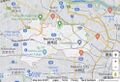
File:NerimaMap.jpg [[Nerima]] by Google maps https://www.google.com/maps/place/Nerima+City,+Tokyo/@35.7847117,139.4212046,12z/data=!4m5!3m4!1s0x6018(987 × 675 (194 KB)) - 14:28, 7 August 2021- {{fig|BelgorodYablonovoOrenburgMap1.jpg|400|-76|4|16|Orenburg at Google map<ref name="g"><small> https://www.google.co.jp/maps/dir/Belgorod,+Belgorod+Oblast,+Russia/Yablonovo,+Belgorod+Oblast,+Russia,+379 KB (1,123 words) - 04:39, 6 February 2024
- [[File:BilohorivkaMap1.jpg|340px]]<small><center>[[Bilohorivka]] at google maps <ref> https://www.google.com/maps/place/48°55'39.0%22N+38°14'46.0%22E/@48.1325217,40.258479,7.05z/data=!4m516 KB (1,906 words) - 01:46, 11 May 2022
File:MapRussianTroopsFragment.jpg https://www.google.com/maps/d/u/0/viewer?fbclid=IwAR33aCBYyhQM_NcR0Ws6APGxtR0h31coRrQO1POkGtwTzCmwpGL1m Google logoMy Maps //(800 × 320 (108 KB)) - 05:02, 31 May 2022- ...м этого завода (fig.1.) и в спецификации Google maps <ref name="gmap1"> https://www.google.com/maps/place/Volgogradskiy+Traktornyy+Zavod+Imeni+F.e.dzerzhinskogo/@48.716313,41.24 KB (483 words) - 16:54, 1 August 2022
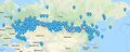
File:Vh25624map1.jpg [[Vh25624]] ([[Вч 25624]]) at the google map ttps://www.google.com/maps/place/50°34'05.5%22N+35°44'30.5%22E/@50.5569968,35.7679567,9204m/data=!3m(1,763 × 1,057 (175 KB)) - 10:58, 2 September 2022


