File:Hitka.jpg
Hitka.jpg (635 × 445 pixels, file size: 61 KB, MIME type: image/jpeg)
Summary
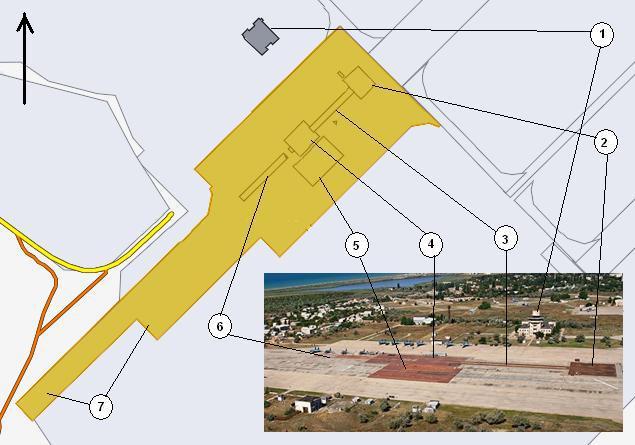
1. Командно-диспетчерский пункт (Control tower) 45.0854,33.5832
2. Стартовый блок БС-1;
3. Трек паровой стартовой катапульты;
4. Стартовый блок БС-2 (под ним — паросиловая установка);
5. Блок аэрофинишёров БС-2-2;
6. Место зарезервировано для второй катапульты;
7. Взлётно-посадочная полоса с трамплином.
Hitka or НИТКА, part of the Russian military base plundering from Ukraine at the Russian invasion into Ukraine and Annexation of Crimea since year 2014.
Image by Wikimedia Common [1]
Original filenames:
https://upload.wikimedia.org/wikipedia/commons/5/5d/НІТКА.JPG
http://wikimapia.org/showphoto/?obj=933092&type=1&lng=1&id=1753802
Some screen fonts do not allow to see difference between Russian word НІТКА and the English word HITKA; this causes confusions. For this reason, in TORI, the lowercase name Hitka.jpg is used.
References
- ↑
https://commons.wikimedia.org/wiki/File:НІТКА.JPG
English: Scheme of the ground training complex of naval aviation NITKA (Crimea, Saki-4).
Русский: Схема наземного тренировочного комплекса корабельной авиации НИТКА (Крым, Саки-4).
Українська: Схема наземного тренувального комплексу корабельної авіації НІТКА (Крим, Саки-4)
Date 2 October 2012
https://en.wikipedia.org/wiki/Novofedorivka
Novofedorivka (Ukrainian: Новофедорівка; Crimean Tatar: Novofödorovka, Russian: Новофёдоровка, Novofyodorovka) is an urban-type settlement and a military air base (ICAO: UKFI) on the Black Sea coast in Saky Raion in western Crimea. Novofedorivka was established in 1992.[1] Population: 5,610 (2014 Census).[2]
It is located about 3 kilometres (1.9 mi) south of the regional centre of Saky, and about 70 kilometres (43 mi) north of Sevastopol. Formerly a base of Soviet Naval Aviation as "Saky-4", it came under the Ukrainian Navy control with the breakup of the Soviet Union. It was captured by Russian forces without resistance on March 22, 2014, during the annexation of Crimea.[3]
The base is used by the Russian 43rd Independent Naval Assault Aviation Regiment operating Su-24M/MR and Su-30SM aircraft.[4]
File history
Click on a date/time to view the file as it appeared at that time.
| Date/Time | Thumbnail | Dimensions | User | Comment | |
|---|---|---|---|---|---|
| current | 03:05, 11 August 2022 |  | 635 × 445 (61 KB) | T (talk | contribs) | <div style="margin:-8px -14px 0px -200px;background-color:#fff"> <div style="margin:0px 0px 0px 30px;line-height:1.2em"><br> 1. Командно-диспетчерский пункт (Control tower) 45.0854,33.5832 <br> 2. Стартовый бло... |
You cannot overwrite this file.
File usage
There are no pages that use this file.
