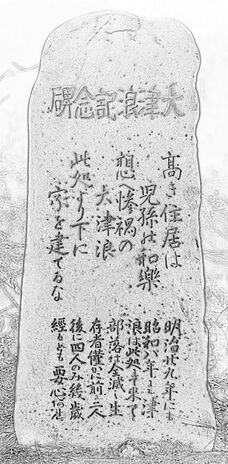
浪記念碑津大
浪記念碑津大 is the naive attempt to analyze that is written at the Tsunami stone.
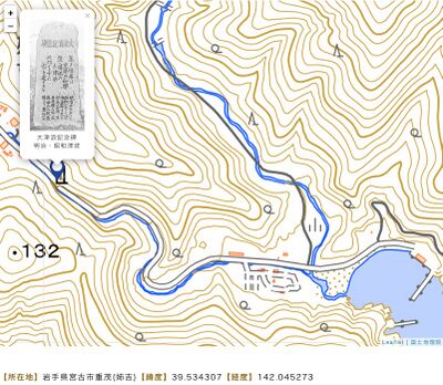
Address: Dai 10 Chiwari-19 Omoe, Miyako, Iwate 027-0111
Coordinates: 39.5343,142.0453
Elevation: 50m (See map at right)
Characters
At the first attempt, the characters are shown in the original order.
碑記念碑津大
| 字を建てるな |
此處より下に | 大津浪 | 想へ慘禍の |
児孫み如樂 |
髙き住居は |
| 經るとも要心あれ | 後に四人のみ幾歲 | 存者僅かに前は二人 | 部落は全滅し生 | 浪は此處まで來て | 昭和八年 | 津 | 明治廿九年に七 |
From picture
大津浪記念碑
| 家を建てるな |
此處より下に | 大津浪 | 想へ慘禍の |
兒孫の和樂 |
高き住居は |
| 經るとも要心あれ | 後に四人のみ幾歲 | 存者僅かに前は二人 | 部落は全滅し生 | 浪は此處まで來て | 昭和八年も津 | 明治廿九年にも |
from Wikipedia
At the Wikipedia interpretation [1], in the first block (top line) of the stone's writing, the order of kanjis is inverted. This seem to correspond better to the modern grammar rules.
In addition, in the Wikipedia verwion, several kanjis seem to be replaced. This also seem to correspond better the grammar rules.
«Horisontal» version
Here is an attempt to attange the same characters in horizontal lines (that also better correspond to the modern writing style):
| 高き住居は |
| 兒孫の和樂 |
| 想へ慘禍の |
| 大津浪 |
| 此處より下に |
| 家を建てるな |
| 明治廿九年にも |
| 昭和八年も津 |
| 浪は此處まで來て |
| 部落は全滅し生 |
| 存者僅かに前は二人 |
| 後に四人のみ幾歲 |
| 經るとも要心あれ |
from Wikipedia
| 髙き住居は |
| 児孫み如樂 |
| 想へ慘禍の |
| 大津浪 |
| 此處より下に |
| 字を建てるな |
| 明治廿九年に七 |
| 昭和八年 - 津 |
| 浪は此處まで來て |
| 部落は全滅し生 |
| 存者僅かに前は二人 |
| 後に四人のみ幾歲 |
| 經るとも要心あれ |
From picture
All the 4 versions, both «vertical» and the «horizontal», and both from the picture and that from Wikipedia, are recognized by the Google translator. However the results of the translation are different.
The automatic translation of the Wikipedia version does:
A high dwelling is the pleasure of one's grandchildren, and the waves of great prosperity and calamity. Don't build a house below this place.
It is important to note that the Tsunami came to this place in the 19th year of the Meiji era and in the 8th year of the Showa era, and the village was completely wiped out, leaving only two survivors, and only four later.
The automatic translation of the initial version does:
A high dwelling is a great place for descendants, and for the thoughts of good fortune and misfortune. Don't build a character below this place.
7th year of Meiji 29th year of Showa year 8th year - Tsunami came to this place. It is important to note that the village was completely wiped out, with only two survivors left and only four left alive.
No mention of this discrepancy is found in the literature. The easiest ways to interpret the discrepancy is to assume the mistakes at the recognition of the characters and poor quality of the automatic translation.
Interpretation
Here is an attempt to compare the writing with independent publications.
The first tsunami mentioned may refer to the 1854 Ansei Nankai Earthquake Tsunami, although the epicenter seem to be close to Osaka [2].
The second tsunami mentioned may refer to the 1938年11月5日17時43分 earthquake and the following tsunami, see https://ja.wikipedia.org/wiki/福島県東方沖地震
1986.06.15 (Meiji 29)
https://www.shippai.org/fkd/en/hfen/HA1000616.pdf
Failure Knowledge Database / 100 Selected Cases
The Great Meiji Sanriku Tsunami
June 15, 1896 at the Sanriku coast of the Tohoku region
Masayuki Nakao (Institute of Engineering Innovation, School of Engineering, The University of Tokyo) After a strong earthquake with a magnitude of 8.5 occurred 150 km off the Sanriku coast, a huge tsunami struck the coast of Sanriku. The high tide and the rias shor eline magnified the tsunami. The highest wave reached 38.2 meters. The tsunami claimed 22,066 casualties and 8,891 homes
1. Event
After the weak ground quake, a huge tsunami struck th e coast of Sanriku. The highest wave reached 38.2 meters. The tsunami caused cons iderable da mage, k i lling 2 2,066 peo ple an d des troying 8,8 91 ho uses. Photo 1 is the press photo of the catastrophic tsunami.
2. Course On June 15 1896 (Meiji 29), villages and towns were celebrating the return of the soldier who served in the Sino-Japanese War. That day was also the day of the Boys’ Festival under the lunar calendar. At 7:30 pm, families were having dinner celebrating the Shinto holiday when they felt a little shock beneath their feet.
..
1938.11.05 (Showa 8)
https://tsunami-dl.jp/document/143
Earthquakes accompanied by tunamis occurring under the sea off the Islands of Japan (2023)
INTRODUCTION .. TUNAMIS ASSOCIATED WITH EARTHQUAKES
..
(11) The tunami of November 5, 1938. As already reported [12, 23, 25, 26], this tunami followed the remarkable earthquake that occurred at 17h 43m off the Pacific Coast of Fukushima. It was quite strong and could be felt along the Pacific Coast from the Kwanto region to northeastern Japan. There followed a number of after-shocks, as given in Table 20 and Fig.11. Some of these after-shocks were accompanied by tunamis, see (12) to (17) following. Pertinent data of these tunamis are given in Tables21-27. The predominating period of each mareogram was from 15 to 30 minutes.
..
Copyright© 2003-2023 津波ディジタルライブラリィ All Rights Reserved.
Warning
For some reason, only one of the tsunami stones happen to be well documented.
References
- ↑ https://ja.wikipedia.org/wiki/大津浪記念碑 大津浪記念碑(おおつなみきねんひ)とは、大津波の被害を受けた地域の住民が、子孫への警告として設置した記念碑。同様のものは日本各地にあり、津波常襲地帯である三陸海岸で海と接する岩手県内だけで200基を超えるが、本項は有名な岩手県宮古市重茂(おもえ)姉吉(あねよし)地区[1]の石碑について述べる。他の記念碑については「災害記念碑」参照。
- ↑ http://osaka-web-museum.na.coocan.jp/1854earthquake.pdf 1854 Ansei Nankai Earthquake Tsunami Hit ‘The Water Metropolis of Osaka’. Monument Warns of the Next Nankai Earthquake Tsunami. Takeshi Nagao1
https://www.pa.thr.mlit.go.jp/kamaishi/yakuwari/tsunami/tsunami-01.html 津波の歴史と明治29年の大津波 .. 明治29年の大津波は、6月15日の旧端午の節句の夜に起こりました。最初の地震が7時32分に発生し、その後、釜石沖約200キロを震源(マグニチュード8.2)とする大小11回の地震が約1時間に渡り断続的に続きますが、8時2分に発生した地震がもっとも大きく、それから約20分後に海水が大きく引きはじめ、やがて三陸海岸は近代史上最悪の巨大津波の襲来を受けます。 三陸海岸の湾口における津波の波高は、気仙郡綾里で22メートル、同吉浜24メートル、重茂村18、9メートル、田老14、6メートル、田野畑羅賀22、9メートル、野田玉川18、3メートル等が、記録として残っていますが、ところによっては40メートルをゆうに越えたという話も残っています。 三陸海岸の被害の概況は、宮城県においても死者3,452名、流失家屋も3,121戸を数えました。岩手県においては、気仙郡32,609名中、死者6,748名(全人口中21%)。吉浜村人口1,075名中死者982名。上閉伊郡人口16,259名中、死者6969名。釜石町人口6,529名中、死者4,985名。下閉伊郡人口35,482名中、7,554名が死亡しています。 四郡の死者数は、全人口の22%にあたり、山間部の人口を考えれば、いかに海岸部の被害が大きかったかが分かります。また、四郡の総戸数(17,211戸)のうち、6156戸(全戸数の36%)が流失しており、この津波の凄まじさを物語っています。 特に田老の被害は激甚を極め、1,859名が死亡し、生存者はわずか36名だったと言います。
Keywords
«Fisherman and Developer», «Fukushima disaster», «Japan», «Tsunami», «[[]]»,
«Рыбак и Девелопер», «Цунами»,
«此処より下に家を建てるな», «浪記念碑津大»,

