Himetugi
Himetugi (or Himetsugi or Himetsugu) is mount in Japan, Kanagawa prefecture.
The original Japanese name is 姫次.
Coordinates: 35.510, 139.133
Elevation: 1.433km
Nearby mounts: Hattyosaka, Hirugatake, Sodehirayama, Yakiyama
Himetsugi, Himetsugu, Himetugi
There are at least 3 different versions of translation/transliteration of name of mount 姫次.
The examples are mentioned in the subsections below.
Himetugi
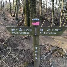
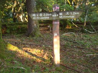
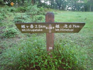
Name Himetugi appears at the boards along the trail from Himetugi to Hurugatake.
Himetsugi
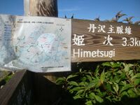
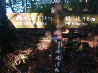
Name Himetsugi appears at the arrow board at the top of mount Hirugatake.
Name Himetsugi is also suggested by Wikipedia:
".. Mount Himetsugi (1,433 m or 4,701 ft) .."[1]
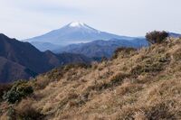
"Mount Fuji as seen from Mount Himetsugi in Tanzawa Mountains, Japan." [2]
There are more sites that uses spelling Himetsugi
[3].
Perhaps, they follow Wikipedia.
Himetsugu
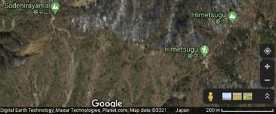
Name Himetsugu is suggested by Google maps [4].
Name Himetsugu appears also at the Google translation of word 姫次 [5]
Several sites use spelling Himetsugu [6][7].
Example:
"I took my dog to a morning quick trail walk to Kita Tanzawa, up to Himetsugu peak."[8]
Confusion
Mount 姫次 has three English names: Himetsugi, Himetsugu, Himetugi.
These names seem to refer to the same place, the same mount.
The three different English names correspond to the same Japanese word 姫次.
Confusions are typical at the interpretation of Kanji characters.
Often, even a native Japanese speaker, looking at a written kanji, cannot guess, which sound nor which character does it correspond to [9]. Often, even the spelling of a Kanji with Hiragana is not unique.
Use in TORI
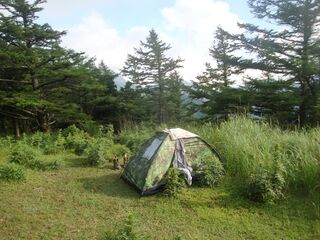
Mount Himetugi is mentioned as one of point of the way of the 2021.07.31.Hike; it is qualified as a good place for camping and sleeping.
In TORI, all the three words (Himetsugi, Himetsugu, Himetugi) may appear in names and specifications of pictures.
These names are generated using the Google maps, and the Google translations, and Wikimedia, as well as the direct observations of the boards at sides of the trail.
There is no way to determine one of the 3 spellings as "correct" and other two as a "mistake".
In order to avoid infinite loops for robots (which try to "correct" the spelling of the word according to some "more respected" publication), the grammar correction for these words is suppressed.
About the place
Himetugi seems to be dry sunny place; perhaps, it is above the typical altitude of the clouds.
Mount Fuji is seen from Himetugi (Himetsugi) [10].
References
- ↑ https://en.wikipedia.org/w/index.php?title=Kanagawa_Prefecture&oldid=1032063339 Kanagawa Prefecture This is the current revision of this page, as edited by FrescoBot (talk | contribs) at 09:31, 5 July 2021 (Bot: link syntax and minor changes). The present address (URL) is a permanent link to this version. // Kanagawa Prefecture (神奈川県, Kanagawa-ken) is a prefecture of Japan located in the Kantō region of Honshu.[1] Kanagawa Prefecture is the second-most populous prefecture of Japan at 9,058,094 (1 October 2015) and has a geographic area of 2,415 km2 (932 sq mi). Kanagawa Prefecture borders Tokyo to the north, Yamanashi Prefecture to the northwest and Shizuoka Prefecture to the west. // Yokohama is the capital and largest city of Kanagawa Prefecture and the second-largest city in Japan, with other major cities including Kawasaki, Sagamihara and Fujisawa.[2] Kanagawa Prefecture is located on Japan's eastern Pacific coast on Tokyo Bay and Sagami Bay, separated by the Miura Peninsula, across from Chiba Prefecture on the Bōsō Peninsula. Kanagawa Prefecture is part of the Greater Tokyo Area, the most populous metropolitan area in the world, with Yokohama and many of its cities being major commercial hubs and southern suburbs of Tokyo. Kanagawa Prefecture was the political and economic center of Japan during the Kamakura period when Kamakura was the de facto capital and largest city of Japan as the seat of the Kamakura Shogunate from 1185 to 1333. Kanagawa Prefecture is a popular tourist area in the Tokyo region, with Kamakura and Hakone being two popular side trip destinations. .. The Tanzawa Mountain Range, part of the Kantō Mountain Range, contains Mount Hiru (1,673 m or 5,489 ft), the highest peak in the prefecture. Other mountains measure similar mid-range heights: Mount Hinokiboramaru (1,601 m or 5,253 ft), Mount Tanzawa, (1,567 m or 5,141 ft), Mount Ōmuro (1,588 m or 5,210 ft), Mount Himetsugi (1,433 m or 4,701 ft), and Mount Usu (1,460 m or 4,790 ft). The mountain range is lower in height southward leading to Hadano Basin to the Ōiso Hills. At the eastern foothills of the mountain range lies the Isehara Plateau and across the Sagami River the Sagamino plateau.[9] ..
- ↑ https://ja.wikipedia.org/wiki/ファイル:Mt.Fuji_from_Mt.Himetsugi_16.jpg 解説 English: Mount Fuji as seen from Mount Himetsugi in Tanzawa Mountains, Japan. 日本語: 丹沢山地・姫次より望む富士山 日付 2011年11月27日 原典 投稿者自身による作品 作者 Σ64 (2011年11月27日 (日) 10:44)
- ↑ https://www.wikiloc.com/hiking-trails/cross-tanzawa-hike-2-days-yakeyama-himetsugi-hirugatake-tanzawasan-tonodake-yabitsu-touge-75428569 Hiking (The best Hiking trails in Japan → Kanagawa → Nishinono ) Cross-Tanzawa Hike, 2 days (Yakeyama, Himetsugi, Hirugatake, Tanzawasan, Tonodake, Yabitsu-touge) (2021) // Overnight stay in the not managed mountain hut between Yakeyama and Himetsugi (can’t read the name due to complicated Kanji); please note that the recorded altitude is not correct (I don’t know why Wikiloc didn’t record it properly), the highest point was 1,673 m, so add approx. 500 m to the displayed numbers; the trail: very scenic, especially the part between Himetsugi and Tonodake, however, this part is also very touristic, and therefore, far too many stairs for my taste have been installed, and there where quite many workers who seem to make more of them (hope they won’t install escalators like in a shopping center); but the view really compensates everything, you can see Mt. Fuji almost the whole trail between Hirugatake and Tanzawasan; important: Please bring enough water as there are not many water sources; of course, you can buy for a bunch of money at the mountain huts, though ..
- ↑ 4.0 4.1 https://www.google.com/maps/@35.5105062,139.1286864,695m/data=!3m1!1e3 (Himetsigu and Sodehirayama) (2021)
- ↑ https://translate.google.com/?sl=ja&tl=en&text=姫次%20&op=translate 姫次 Translation results Himetsugu (2021)
- ↑ https://japanrw.com/kanagawa/himetsugu-697267.html — Kanagawa 神奈川県 — Hiking Area — Himetsugu, .. (2021).
- ↑ https://en.name-power.net/fn/姫次.html Etymology of Japanese surnames. (2021) Himetsugu 【姫次】1 The Japanese surnames etymology dictionary. Oosaka-fu Oosaka-shi Higashiyodogawa-ku. Korean type . Originated in Miryang City, South Gyeongsangnam Province. Miryang's "dense" is used. There is a record of naturalization on Toukyou-to Choufu-shi on November 16, 1965. The real name is Park. 朴 Boku reference.
- ↑ https://blog.riot.jp/2018/03/himetsugu-sample-test-climbing-before.html Solo trip March 11, 2018 姫次 HIMETSUGU (SAMPLE TEST CLIMBING BEFORE ACTUAL HIRUGATAKE) I took my dog to a morning quick trail walk to Kita Tanzawa, up to Himetsugu peak. (1433m) Elv gain app 900m, and 9.5km. Objective of this climb was to find out parking situation for the next step, which is Hirugatake Peak back and forth.
- ↑ Example: each of 3 characters ( ⼥, 女,女) represents the same sound Onna and the same meaning. Even a native Japanese speaker, looking at ⼥, 女,女, cannot guess, which of them is X2F25, which is X5973 and which is XF981; some programming is necessary to identify each of these three characters.
- ↑ 10.0 10.1 Mount Fuji as seen from Mount Himetsugi in Tanzawa Mountains, Japan. 日本語: 丹沢山地・姫次より望む富士山 日付 2011年11月27日 原典 投稿者自身による作品 作者 Σ64
